Last Updated on December 29, 2024 9:26 am
NCC011-023-027-292000-
/O.NEW.KGSP.FA.Y.0194.241229T1422Z-241229T2000Z/
/00000.N.ER.000000T0000Z.000000T0000Z.000000T0000Z.OO/
Avery NC-Burke NC-Caldwell NC-
922 AM EST Sun Dec 29 2024
…FLOOD ADVISORY IN EFFECT UNTIL 3 PM EST THIS AFTERNOON…
- WHAT…Flooding caused by excessive rainfall is expected.
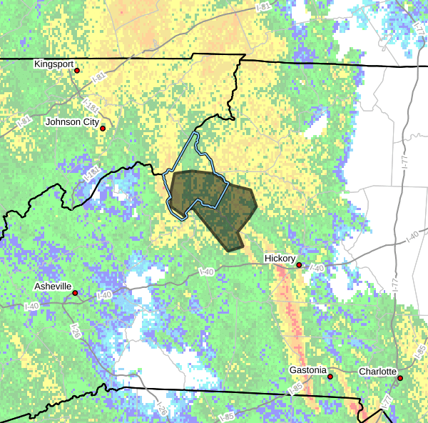
- WHERE…A portion of western North Carolina, including the
following counties, Avery, Burke and Caldwell. - WHEN…Until 300 PM EST.
- IMPACTS…Minor flooding in low-lying and poor drainage areas.
- ADDITIONAL DETAILS…
- At 916 AM EST, Doppler radar indicated heavy rain due to
thunderstorms. Minor flooding is ongoing or expected to begin
shortly in the advisory area. Between 2 and 2.5 inches of
rain have fallen. Continue to monitor rising stream levels
along the North Toe River where flooding of low-lying areas
are likely, especially throughout greater Newland.
Along and East of the Blue Ridge, water levels along the
Linville and Johns Rivers, as well as Wilson and Mulberry
Creeks will continue to rise as flooding of low lying areas
within these watersheds are likely as well.
- Additional rainfall amounts of 0.5 to 1 inch are expected
over the area. This additional rain will result in minor
flooding. - Some locations that may experience flooding include…
Newland, Crossnore, Sugar Mountain, B.R. Parkway-Linville
Falls To Grandfather, Linville Falls, Table Rock, B.R.
Parkway-Little Switzerland To Linville, Edgemont, Jonas
Ridge, Pineola, Linville, Globe, Upton, Collettsville,
Altamont, Ingalls, Oak Hill and Minneapolis. - http://www.weather.gov/safety/flood
PRECAUTIONARY/PREPAREDNESS ACTIONS…
When it is safe to do so, please report flooding or landslides
threatening roads or property to the National Weather Service
Greenville-Spartanburg by calling toll free, 1, 800, 2 6 7, 8 1 0 1,
by posting on our Facebook page, or via X using hashtag NWSGSP. Your
message should describe the specific location where impacts occurred
and the depth of flooding observed.
Be aware of your surroundings and do not drive on flooded roads.


