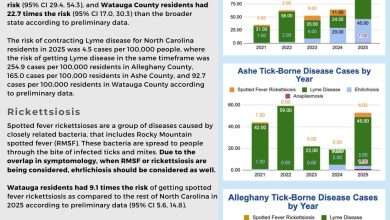
Last Updated on February 9, 2025 2:42 pm
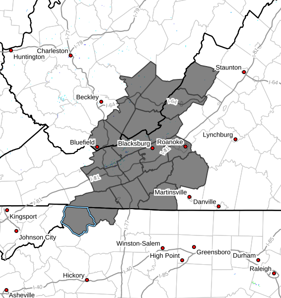
NCZ001-002-VAZ010>020-022-032-033-WVZ042>044-507-508-100345-
/O.NEW.KRNK.WS.A.0004.250211T0900Z-250212T2100Z/
Ashe-Alleghany NC-Bland-Giles-Wythe-Pulaski-Montgomery-Grayson-
Carroll-Floyd-Craig-Alleghany VA-Bath-Roanoke-Patrick-Franklin-
Mercer-Summers-Monroe-Eastern Greenbrier-Western Greenbrier-
Including the cities of Rocky Mount, Blacksburg, Independence,
Galax, Whitetop, Salem, Quinwood, Troutdale, Duo, Pulaski,
Lewisburg, Wytheville, West Jefferson, Alderson, Covington,
Union, Floyd, Radford, New Castle, Sparta, Bluefield, Flat Top,
Pearisburg, White Sulphur Springs, Roanoke, Rainelle, Stuart,
Bland, Clifton Forge, Hinton, Hix, Volney, and Hot Springs
234 PM EST Sun Feb 9 2025
…WINTER STORM WATCH IN EFFECT FROM LATE MONDAY NIGHT THROUGH
WEDNESDAY AFTERNOON…
- WHAT…Heavy mixed precipitation possible. Total snow
accumulations of 1 to 6 inches and ice accumulations around three
tenths of an inch possible. Some light sleet accumulations as well. - WHERE…Portions of northwest North Carolina, southwest Virginia,
and southeast West Virginia. - WHEN…From late Monday night through Wednesday afternoon.
- IMPACTS…Ice accumulation on power lines and tree limbs may cause
power outages. Power outages and tree damage are possible due to
the ice. The hazardous conditions could impact the Tuesday morning
and evening commutes.
PRECAUTIONARY/PREPAREDNESS ACTIONS…
Monitor the latest forecasts for updates on this situation.