Last Updated on May 13, 2025 11:25 am
NCC189-131715-
/O.EXT.KRNK.FA.W.0018.000000T0000Z-250513T1715Z/
/00000.0.ER.000000T0000Z.000000T0000Z.000000T0000Z.OO/
Watauga NC-
1113 AM EDT Tue May 13 2025
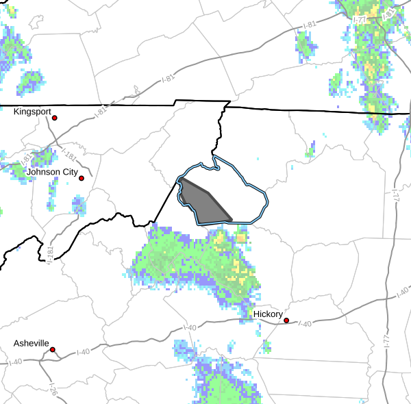
…FLOOD WARNING NOW IN EFFECT UNTIL 115 PM EDT THIS AFTERNOON…
* WHAT…Small stream flooding caused by excessive rainfall
continues.
* WHERE…A portion of northwest North Carolina, including the
following county, Watauga.
* WHEN…Until 115 PM EDT.
* IMPACTS…Flooding of rivers, creeks, streams, and other low-lying
and flood-prone locations is imminent or occurring. Low-water
crossings are inundated with water and may not be passable.
* ADDITIONAL DETAILS…
– At 1111 AM EDT, The Watauga River near Sugar Grove is falling
but is still above minor flood stage and minor flooding will
continue into early afternoon.
– This includes the following streams and drainages…
Laurel Creek, Laurel Fork, Beaverdam Creek, Clark Creek,
Dutch Creek, Valley Creek, Pond Creek, Brushy Fork, Grassy
Gap Creek, George Gap Branch, Watauga River, Cove Creek,
Spice Bottom Creek, Beech Creek, Craborchard Creek and Hayes
Branch.
Flooding impacts will continue, but no additional rainfall is
expected.
– Some locations that will experience flooding include…
Blowing Rock, Beech Mountain, Foscoe, Seven Devils, Valle
Crucis, Rominger and Moses Cone Memorial Park.
– http://www.weather.gov/safety/flood
PRECAUTIONARY/PREPAREDNESS ACTIONS…
Turn around, don't drown when encountering flooded roads. Most flood
deaths occur in vehicles.
Be especially cautious at night when it is harder to recognize the
dangers of flooding.
When it is safe to do so, please send your reports of flooding,
including mudslides or flooded roads, to the National Weather
Service by calling toll free at 1…8 6 6…2 1 5…4 3 2 4. Reports
and pictures can also be shared on the National Weather Service
Blacksburg Facebook page and on Twitter.


