Last Updated on January 29, 2026 9:41 am
URGENT – WINTER WEATHER MESSAGE
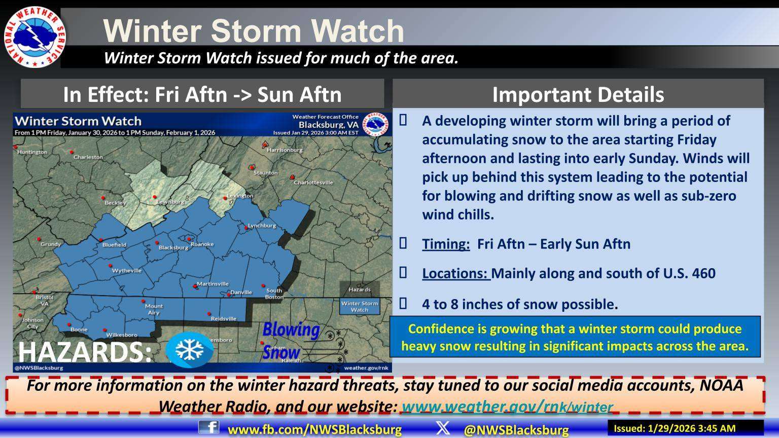
National Weather Service Blacksburg VA
237 AM EST Thu Jan 29 2026
NCZ001>006-018>020-VAZ007-009>018-022-023-032>035-043>047-058-059-
WVZ042-291915-
/O.NEW.KRNK.WS.A.0002.260130T1800Z-260201T1800Z/
Ashe-Alleghany NC-Surry-Stokes-Rockingham-Caswell-Watauga-Wilkes-
Yadkin-Tazewell-Smyth-Bland-Giles-Wythe-Pulaski-Montgomery-
Grayson-Carroll-Floyd-Craig-Roanoke-Botetourt-Patrick-Franklin-
Bedford-Amherst-Henry-Pittsylvania-Campbell-Appomattox-Buckingham-
Halifax-Charlotte-Mercer-
Including the cities of Tazewell, Sparta, Wytheville, Whitetop,
Galax, Keysville, Independence, Salem, Stuart, Roanoke, Volney,
New Castle, West Jefferson, Rocky Mount, Floyd, Dobson,
Wilkesboro, Yadkinville, Amherst, Bland, Appomattox, Eden,
Fincastle, Yanceyville, Lynchburg, Flat Top, Bedford, Bluefield,
Danbury, Boone, Marion, Martinsville, South Boston, Troutdale,
Radford, Pulaski, Pearisburg, Danville, and Blacksburg
237 AM EST Thu Jan 29 2026
…WINTER STORM WATCH IN EFFECT FROM FRIDAY AFTERNOON THROUGH SUNDAY
AFTERNOON…
- WHAT…Heavy snow possible. Total snow accumulations between 4 and
8 inches possible with the highest amounts south of Route 460. - WHERE…Portions of northwest North Carolina and southwest
Virginia, and Mercer County in southeast West Virginia. - WHEN…From Friday afternoon through Sunday afternoon.
- IMPACTS…Travel could become very difficult during Friday and the
upcoming weekend due to the snow. The hazardous conditions could
impact the Friday evening commute. - ADDITIONAL DETAILS…Gusty winds during Saturday night into Sunday
may cause blowing and drifting snow, which could cause poor
visibility.
PRECAUTIONARY/PREPAREDNESS ACTIONS…
Monitor the latest forecasts for updates on this situation.