Last Updated on May 22, 2025 2:43 pm
NEBO, N.C., May 22, 2025 – The USDA Forest Service has updated its list of trails, roads and recreation sites reopened since Hurricane Helene on the Pisgah National Forest’s Grandfather Ranger District ahead of Memorial Day weekend.
Thanks to the help of local partners and volunteers and Forest Service personnel assisting from across the country, the Grandfather Ranger District has cleared several thousand downed trees and mitigated hazardous washouts, landslides and debris flows, culminating in the reopening of more than 250 miles of trails and 150 miles of roads across McDowell, Burke, Caldwell and Avery counties.
New hazards from Hurricane Helene exist across this area of the Pisgah National Forest. Even in areas that are open, trees may be down across trails, and areas along creeks and rivers may be hard to follow because of erosion. Visitors should also anticipate finding unknown underwater hazards in waterways. In addition, larger crowds can be expected over the holiday weekend, especially in more popular areas such as the Hawksbill Trail in Linville Gorge and Catawba Falls in Old Fort. The public should use extra caution when spending time in the Pisgah this summer.
Approximately 40 miles of trails remain closed, including multiple trails in the Old Fort area and portions of the Linville Gorge Trail. Four recreation sites remain closed including the Wilson Creek Day Use Area and the Table Rock Picnic Area. Several roads are now open to hiking, running, biking and equestrian use but remain closed to motor vehicles, including Curtis Creek Road. Five roads in McDowell County remain impassable because of extreme damage.
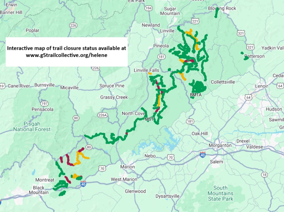
The full list of what’s open and closed and an interactive map at www.g5trailcollective.org/helene.
The following recreation sites and trails remain closed:
McDowell County:
· Curtis Creek Campground
· Gateway Trailhead (trails are open)
· Bernard Mountain Trailhead (trails are open)
· Lower Heartbreak Ridge Trail (TR207)
· Curtis Creek Fishing Access (TR1110)
· Newberry Creek Trail (TR210)
· Snooks Nose Trail (TR211)
· Hickory Branch Trail (TR213)
· Sugar Cove Trail (TR219)
· Portions of the Meadows Loop Trail (TR1107 – see map)
· Section of the Mountains to Sea Trail where it crosses the North Fork River (bridge out)
Burke County:
· Table Rock Picnic Area (trails are open)
· Sections of the Linville Gorge Trail (TR231 – see map)
· Greentown Shortcut Trail (TR268A)
Caldwell County:
· Wilson Creek Gorge Day Use Area (no activities permitted in area during closure)
· Harper Creek Trail (TR260)
· Wilson Creek Trail (TR258)
· Wilson Creek Spur Trail (TR258A)
The following roads remain closed to motorized vehicles, but are open to recreational us on foot, bike and horseback:
McDowell County:
· Curtis Creek Road (FSRD482 – gated below campground)
· Jarrett Creek Road (FSRD4030 – gated before Gateway Trailhead – bridge out)
Burke County:
· New Gingercake Road (FSRD496)
· Table Rock Road (FSRD99 – paved section to Table Rock)
Caldwell/Avery Counties:
· Thunderhole Road (FSRD4071)
· Lost Cove Road (FSRD 464A)
The following roads in McDowell County are not passable, even for non-motorized traffic because of extreme damage. Use of these roads on foot, bike or horseback is not recommended:
· Newberry Creek Road (FSRD482A)
· Sugar Cove Road (FSRD1188)
· Good Cemetery Road (FSRD4008)
· Little Buck Road (FSRD470)
· Parris Creek Road (FSRD1186)
For more information openings and closings across the entire Pisgah National Forest, visit www.fs.usda.gov/nfsnc and follow the National Forests in North Carolina on Facebook at www.facebook.com/nfsnc.