


Last Updated on June 17, 2025 4:27 pm
NCC009-189-193-172100-
/O.NEW.KRNK.SV.W.0090.250617T1955Z-250617T2100Z/
BULLETIN – IMMEDIATE BROADCAST REQUESTED
Severe Thunderstorm Warning
National Weather Service BLACKSBURG VA
355 PM EDT Tue Jun 17 2025
The National Weather Service in BLACKSBURG has issued a
* Severe Thunderstorm Warning for…
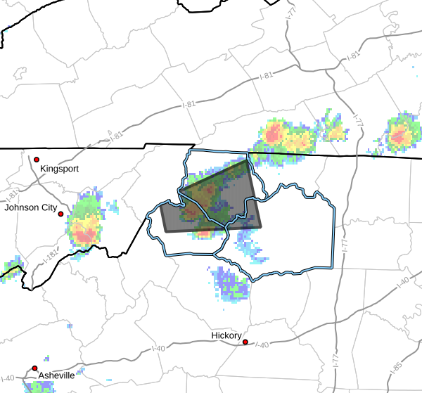
Northwestern Wilkes County in northwestern North Carolina…
Central Watauga County in northwestern North Carolina…
Central Ashe County in northwestern North Carolina…
* Until 500 PM EDT.
* At 354 PM EDT, a severe thunderstorm was located over Silverstone,
or over Sugar Grove, moving east at 20 mph.
HAZARD…60 mph wind gusts and quarter size hail.
SOURCE…Radar indicated.
IMPACT…Hail damage to vehicles is expected. Expect wind damage
to roofs, siding, and trees.
* Locations impacted include…
Jefferson…
West Jefferson…
Glendale Springs…
Deep Gap…
Ashland…
Wilbar…
and Sugar Grove.
PRECAUTIONARY/PREPAREDNESS ACTIONS…
Prepare immediately for large hail and damaging winds, as well as
deadly cloud to ground lightning. For your safety, move to an
interior room on the lowest floor of a sturdy building. Stay away
from windows.
Torrential rainfall is occurring with this storm, and may lead to
flash flooding. Do not drive your vehicle through flooded roadways.
When it is safe to do so, please send your reports of hail of any
size, as well as reports of any wind damage, including downed trees
or large limbs, to the National Weather Service by calling toll free
at 1…8 6 6…2 1 5…4 3 2 4. Reports and pictures can also be
shared on the National Weather Service Blacksburg Facebook page and
on X.


