Last Updated on January 21, 2026 1:08 pm
URGENT WEATHER ALERT: January 21, 2026
The National Weather Service has issued a Winter Storm Watch for our region, warning of potentially dangerous conditions from Saturday morning through Monday afternoon.
What to Expect
Precipitation Forecast
- Total Accumulation: 8 to 14 inches of snow and sleet
- Significant winter weather expected across the region
Potential Impacts
- Extremely difficult or impossible travel conditions
- Potential disruption to Monday morning commute
- Severe winter weather affecting multiple counties
Affected Areas
The storm watch covers:
- North central and northwest North Carolina
- Including Watauga, Ashe, and Wilkes Counties
- Parts of Virginia
- Southeast West Virginia
Preparedness Recommendations
Personal Safety
- Stay indoors until conditions improve
- When outside, dress in multiple layers
- Cover exposed skin to prevent frostbite and hypothermia
- Wear gloves, scarf, and hat to retain body heat
Travel Guidance
- Strongly Advised: Delay all non-essential travel
- If travel is absolutely necessary:
- Drive with extreme caution
- Carry a comprehensive winter storm emergency kit
Winter Storm Kit Essentials
- Tire chains
- Booster cables
- Flashlight
- Shovel
- Extra blankets and clothing
- Water
- First aid kit
- Emergency survival supplies
Stay Informed
- Monitor local weather forecasts
- Follow WataugaOnline for real-time updates
- Sign up for emergency alerts
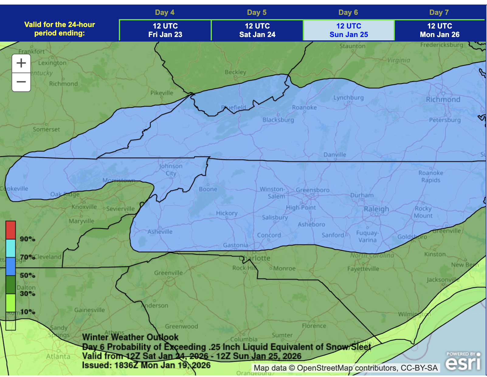
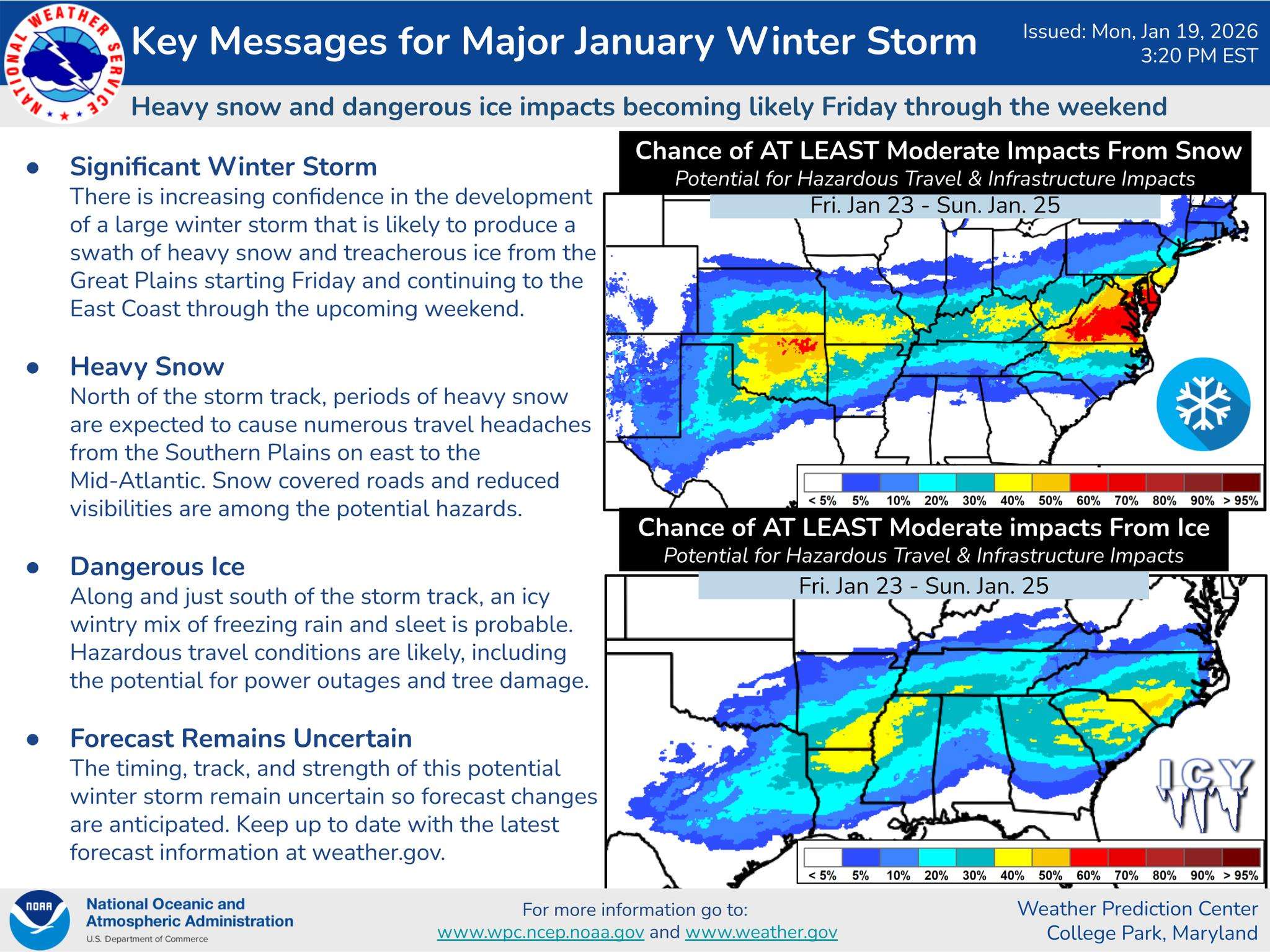
UPDATE WEDNESDAY JANUARY 21 – High Country Winter Storm: Significant Weekend Impact Likely
The National Weather Service has increased confidence in a major winter storm set to impact the High Country this weekend, with predictions suggesting the most substantial winter event in over five years.
Storm Forecast
Key meteorological observations include:
- 60-70% chance of 10+ inches of snow
- Storm likely Saturday afternoon through Sunday night
- Potential for snow or wintry mix near NC/VA border
- Moisture levels trending upward, increasing storm impact
Storm Characteristics
Meteorologists note several critical factors:
- Storm system currently tracked in Pacific Ocean
- Aircraft reconnaissance performed Tuesday to gather data
- Latest models showing potential northward track
- Snow expected as primary precipitation type
Post-Storm Conditions
Following the winter storm, extreme cold is anticipated:
- Temperatures near zero degrees
- Wind chills -10 to -15 in higher elevations
- Below freezing conditions through midweek
- Minimal snow/ice melting expected
Community Preparedness
Residents are advised to:
- Limit non-essential travel
- Prepare winter emergency supplies
- Protect vulnerable residents and pets
- Ensure home heating systems are functional
- Check on elderly neighbors
WataugaOnline will provide continuous updates as the forecast evolves.
BOONE, NC – The National Weather Service is monitoring a potential winter weather system that could impact the High Country this weekend, with forecasters indicating a growing possibility of snow from Friday afternoon through Sunday morning.
Storm Overview
A complex weather pattern is setting up across the southern United States, with conditions potentially favorable for winter precipitation in Watauga, Ashe, and Avery Counties. The current forecast suggests a winter storm system may develop, bringing a chance of snowfall to the region.
Key Details
- Potential Storm Period: Friday afternoon through Sunday morning
- Primary Precipitation: Snow
- Forecast Confidence: Moderate uncertainty remains
Forecast Uncertainty
Meteorologists emphasize that while the overall storm system appears likely, critical details remain fluid. Specific considerations include:
- Exact timing of storm arrival
- Total precipitation accumulation
- Potential for mixed precipitation
The 540 thickness line may influence precipitation type, with a slight possibility of freezing rain, though snow remains the primary projected precipitation. Residents are advised to monitor ongoing forecasts closely.
Community Preparedness
While it's too early to determine specific impacts, WataugaOnline recommends residents:
- Stay informed through local weather updates
- Prepare winter emergency kits
- Check road conditions before traveling
WataugaOnline will provide continuous updates as the forecast develops. Stay tuned to our website and social media channels for the latest information.