


Last Updated on June 17, 2025 4:21 am
NCZ001>005-018>020-VAZ007-009>020-022>024-032>035-043>045-WVZ042>044-
507-508-171915-
/O.NEW.KRNK.FA.A.0012.250617T1500Z-250618T0200Z/
/00000.0.ER.000000T0000Z.000000T0000Z.000000T0000Z.OO/
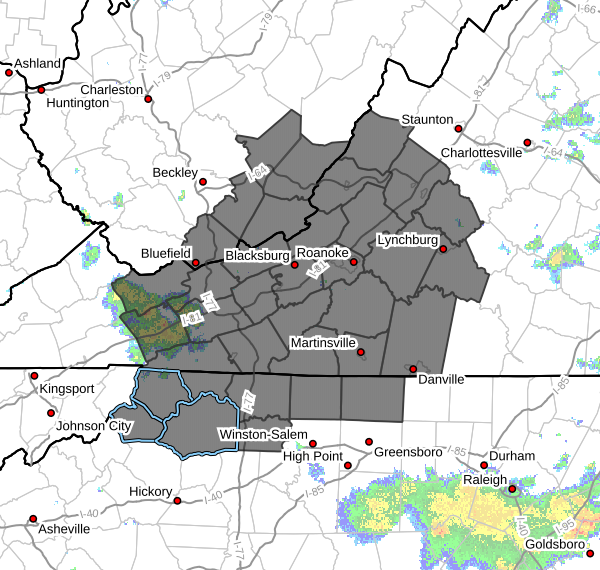
Ashe-Alleghany NC-Surry-Stokes-Rockingham-Watauga-Wilkes-Yadkin-
Tazewell-Smyth-Bland-Giles-Wythe-Pulaski-Montgomery-Grayson-
Carroll-Floyd-Craig-Alleghany VA-Bath-Roanoke-Botetourt-
Rockbridge-Patrick-Franklin-Bedford-Amherst-Henry-Pittsylvania-
Campbell-Mercer-Summers-Monroe-Eastern Greenbrier-Western
Greenbrier-
Including the cities of Hix, Flat Top, Pearisburg, Alderson,
Lewisburg, Marion, Danbury, Tazewell, Rainelle, Sparta, New
Castle, Pulaski, Hot Springs, Fincastle, Danville, Bland, Hinton,
Lynchburg, Eden, Quinwood, Wilkesboro, Independence, Lexington,
Bedford, Floyd, Wytheville, Stuart, Whitetop, West Jefferson,
Clifton Forge, Covington, Amherst, Radford, Dobson, Union,
Troutdale, Blacksburg, Rocky Mount, Bluefield, Martinsville,
Volney, Galax, White Sulphur Springs, Buena Vista, Salem, Duo,
Roanoke, Boone, and Yadkinville
247 AM EDT Tue Jun 17 2025
…FLOOD WATCH IN EFFECT FROM 11 AM EDT THIS MORNING THROUGH THIS
EVENING…
- WHAT…Flooding caused by excessive rainfall is possible.
- WHERE…Portions of North Carolina, including the following areas,
Alleghany NC, Ashe, Rockingham, Stokes, Surry, Watauga, Wilkes and
Yadkin, Virginia, including the following areas, Alleghany VA,
Amherst, Bath, Bedford, Bland, Botetourt, Campbell, Carroll,
Craig, Floyd, Franklin, Giles, Grayson, Henry, Montgomery,
Patrick, Pittsylvania, Pulaski, Roanoke, Rockbridge, Smyth,
Tazewell and Wythe, and southeast West Virginia, including the
following areas, Eastern Greenbrier, Mercer, Monroe, Summers and
Western Greenbrier. - WHEN…From 11 AM EDT this morning through this evening.
- IMPACTS…Excessive runoff may result in flooding of rivers,
creeks, streams, and other low-lying and flood-prone locations.
Creeks and streams may rise out of their banks. Flooding may occur
in poor drainage and urban areas. Low-water crossings may be
flooded. Extensive street flooding and flooding of creeks and
rivers are possible. - ADDITIONAL DETAILS…
- Showers and thunderstorms develop early this afternoon and
into tonight. A nearby frontal boundary will provide focus
for repeated storms to develop. This along with increasing
moisture and previous heavy rainfall will set the stage for
additional flash flooding across the area. - http://www.weather.gov/safety/flood
PRECAUTIONARY/PREPAREDNESS ACTIONS…
You should monitor later forecasts and be alert for possible Flood
Warnings. Those living in areas prone to flooding should be prepared
to take action should flooding develop.


