Last Updated on September 29, 2022 4:04 pm
NCZ033-035>037-056-057-069>072-082-501>504-SCZ009-014-300315-
/O.NEW.KGSP.FA.A.0004.220930T1600Z-221001T1600Z/
/00000.0.ER.000000T0000Z.000000T0000Z.000000T0000Z.OO/
Avery-Alexander-Iredell-Davie-Catawba-Rowan-Lincoln-Gaston-
Mecklenburg-Cabarrus-Union NC-Caldwell Mountains-Greater Caldwell-
Burke Mountains-Greater Burke-York-Chester-
Including the cities of Charlotte, Taylorsville, Hickory, Advance,
Blackstock, Bethlehem, Fork Church, Ingalls, Matthews, Pleasant
Grove, Chester, Gastonia, Valdese, Lincolnton, Patterson, Hiddenite,
Mooresville, Millersville, Sawmills, Banner Elk, Granite Falls,
Stony Point, Newland, Weddington, Crouse, Indian Trail, Kings Creek,
Newton, Catawba, Concord, Trinity, Salisbury, Cornwell, Kannapolis,
Farmington, Ellendale, Huntersville, Lenoir, Monroe, Mocksville,
Rock Hill, St. Stephens, Statesville, Morganton, Jonas Ridge, and
Great Falls
310 PM EDT Thu Sep 29 2022
…FLOOD WATCH IN EFFECT FROM FRIDAY AFTERNOON THROUGH SATURDAY
MORNING…
* WHAT…Flash flooding caused by excessive rainfall is possible.
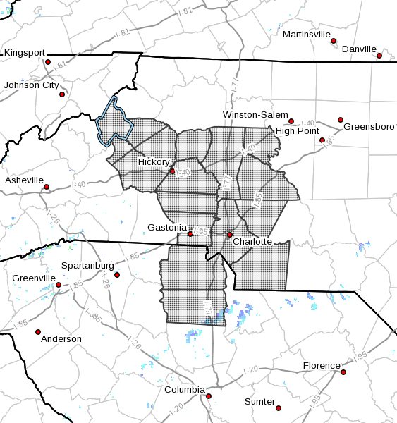
* WHERE…Portions of North Carolina and upstate South Carolina,
including the following areas, in North Carolina, Alexander,
Avery, Burke Mountains, Cabarrus, Caldwell Mountains, Catawba,
Davie, Gaston, Greater Burke, Greater Caldwell, Iredell, Lincoln,
Mecklenburg, Rowan and Union NC. In upstate South Carolina,
Chester and York.
* WHEN…From Friday afternoon through Saturday morning.
* IMPACTS…Excessive runoff may result in flooding of rivers,
creeks, streams, and other low-lying and flood-prone locations.
Flooding may occur in poor drainage and urban areas.
* ADDITIONAL DETAILS…
– Heavy rain associated with Ian is expected to move in across
the western Carolinas on Friday morning. Rain will become
heavy at times across the western Piedmont and northern
foothills of North Carolina, and the eastern Piedmont of
South Carolina, including the Charlotte metro area. As
rainfall piles up, flash flooding will be possible Friday
afternoon and Friday night, particularly in the urban areas
around Charlotte. The heavy rain will lift out Saturday
morning.
– http://www.weather.gov/safety/flood
PRECAUTIONARY/PREPAREDNESS ACTIONS…
A Flood Watch for flash flooding means there is a potential for
rapid onset flooding based on current forecasts. Flash flooding is a
very dangerous situation and may impact areas that do not typically
flood. Please monitor the latest forecasts and be prepared to take
action quickly should Flash Flood Warnings be issued.