


Last Updated on June 9, 2025 7:57 pm
NCC005-171-189-193-100545-
/O.NEW.KRNK.FA.Y.0055.250609T2351Z-250610T0545Z/
/00000.N.ER.000000T0000Z.000000T0000Z.000000T0000Z.OO/
Alleghany NC NC-Surry NC-Watauga NC-Wilkes NC-
751 PM EDT Mon Jun 9 2025
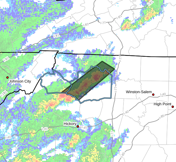
…FLOOD ADVISORY IN EFFECT UNTIL 145 AM EDT TUESDAY…
- WHAT…Flooding caused by excessive rainfall is expected.
- WHERE…Portions of northwest North Carolina, including the
following
counties, in northwest North Carolina, Alleghany NC, Surry, Watauga
and Wilkes. - WHEN…Until 145 AM EDT.
- IMPACTS…Minor flooding in low-lying and poor drainage areas.
Some low-water crossings may become impassable. - ADDITIONAL DETAILS…
- At 750 PM EDT, Doppler radar indicated heavy rain due to
thunderstorms. Minor flooding is expected to begin shortly in
the advisory area. Between 1 and 1.5 inches of rain have
fallen. - This includes the following streams and drainages…
Cove Creek, Camp Branch, Bee Tree Branch, Big Pine Creek, Big
Sandy Creek, Clear Branch, Basin Creek, Cane Creek, Beaver
Creek, Big Bugaboo Creek, Darnell Creek, Brush Creek and
Church Branch.
Additional rainfall amounts of 1 to 2 inches are expected
over the area. This additional rain will result in minor
flooding. - Some locations that will experience flooding include…
North Wilkesboro… Wilkesboro…
Mc Grady… Wilbar…
Traphill… Mountain Park…
Halls Mills… - http://www.weather.gov/safety/flood
PRECAUTIONARY/PREPAREDNESS ACTIONS…
Turn around, don't drown when encountering flooded roads. Most flood
deaths occur in vehicles.
Be especially cautious at night when it is harder to recognize the
dangers of flooding.
When it is safe to do so, please send your reports of flooding,
including mudslides or flooded roads, to the National Weather
Service by calling toll free at 1…8 6 6…2 1 5…4 3 2 4. Reports
and pictures can also be shared on the National Weather Service
Blacksburg Facebook page and on Twitter.


