


Last Updated on June 30, 2025 2:55 pm
NCC189-302200-
/O.NEW.KRNK.FA.Y.0107.250630T1850Z-250630T2200Z/
/00000.N.ER.000000T0000Z.000000T0000Z.000000T0000Z.OO/
Watauga NC-
250 PM EDT Mon Jun 30 2025
…FLOOD ADVISORY IN EFFECT UNTIL 6 PM EDT THIS EVENING…
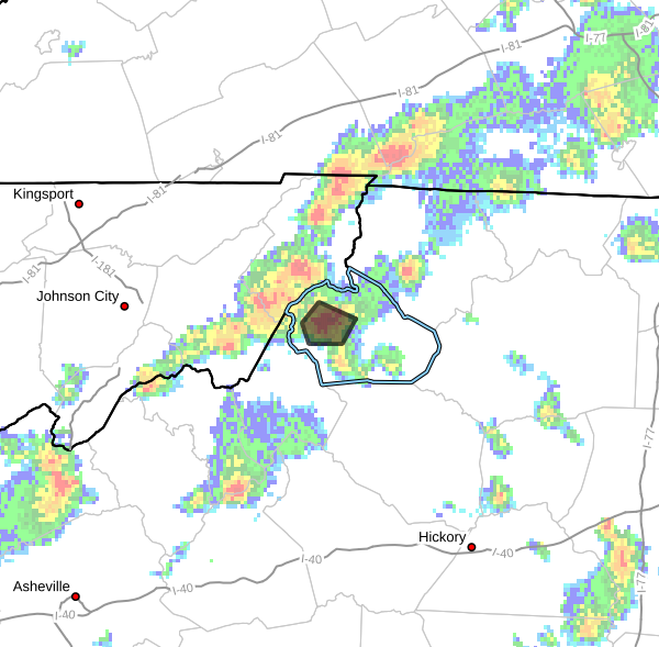
* WHAT…Flooding caused by excessive rainfall is expected.
* WHERE…A portion of northwest North Carolina, including the
following county, Watauga.
* WHEN…Until 600 PM EDT.
* IMPACTS…Minor flooding in low-lying and poor drainage areas.
* ADDITIONAL DETAILS…
– At 250 PM EDT, Doppler radar indicated heavy rain due to
thunderstorms. Minor flooding is ongoing or expected to begin
shortly in the advisory area. Between 0.5 and 1.5 inches of
rain have fallen.
– This includes the following streams and drainages…
Vanderpool Creek, Little Beaverdam Creek, Brushy Fork, Laurel
Fork, Beaverdam Creek, George Gap Branch, Laurel Branch,
Beech Creek, Laurel Creek, Watauga River, Dutch Creek,
Craborchard Creek and Cove Creek.
Additional rainfall amounts of 0.5 to 1.5 inches are expected
over the area. This additional rain will result in minor
flooding.
– Some locations that will experience flooding include…
Sugar Grove… Valle Crucis…
Rominger… Lovill…
– http://www.weather.gov/safety/flood
PRECAUTIONARY/PREPAREDNESS ACTIONS…
Turn around, don't drown when encountering flooded roads. Most flood
deaths occur in vehicles.
When it is safe to do so, please send your reports of flooding,
including mudslides or flooded roads, to the National Weather
Service by calling toll free at 1…8 6 6…2 1 5…4 3 2 4. Reports
and pictures can also be shared on the National Weather Service
Blacksburg Facebook page and on X.


