Last Updated on August 20, 2025 3:04 pm
NCC005-009-189-193-202200-
/O.NEW.KRNK.FA.Y.0199.250820T1858Z-250820T2200Z/
/00000.N.ER.000000T0000Z.000000T0000Z.000000T0000Z.OO/
Alleghany NC NC-Ashe NC-Watauga NC-Wilkes NC-
258 PM EDT Wed Aug 20 2025
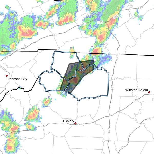
…FLOOD ADVISORY IN EFFECT UNTIL 6 PM EDT THIS EVENING…
- WHAT…Flooding caused by excessive rainfall is expected.
- WHERE…A portion of northwest North Carolina, including the
following counties, Alleghany NC, Ashe, Watauga and Wilkes. - WHEN…Until 600 PM EDT.
- IMPACTS…Minor flooding in low-lying and poor drainage areas.
- ADDITIONAL DETAILS…
- At 257 PM EDT, Doppler radar indicated heavy rain due to
thunderstorms. Minor flooding is ongoing or expected to begin
shortly in the advisory area. Between 1.5 and 2 inches of
rain have fallen. - This includes the following streams and drainages…
Elk Creek, East Prong Roaring River, Call Creek, Cove Creek,
Darnell Creek, Clear Branch, Beaver Creek, Dog Creek, Dugger
Creek, Basin Creek and Church Branch. - Some locations that will experience flooding include…
Jefferson… West Jefferson…
Glendale Springs… Wilbar…
Mc Grady… Laurel Springs…
Deep Gap… - http://www.weather.gov/safety/flood
PRECAUTIONARY/PREPAREDNESS ACTIONS…
Turn around, don't drown when encountering flooded roads. Most flood
deaths occur in vehicles.
When it is safe to do so, please send your reports of flooding,
including mudslides or flooded roads, to the National Weather
Service by calling toll free at 1…8 6 6…2 1 5…4 3 2 4. Reports
and pictures can also be shared on the National Weather Service
Blacksburg Facebook page and on X.