Last Updated on May 6, 2024 12:33 pm
NCC009-061930-
/O.NEW.KRNK.FA.Y.0015.240506T1629Z-240506T1930Z/
/00000.N.ER.000000T0000Z.000000T0000Z.000000T0000Z.OO/
Ashe NC-
1229 PM EDT Mon May 6 2024
…FLOOD ADVISORY IN EFFECT UNTIL 330 PM EDT THIS AFTERNOON…
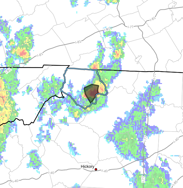
* WHAT…Flooding caused by excessive rainfall is expected.
* WHERE…A portion of northwest North Carolina, including the
following county, Ashe.
* WHEN…Until 330 PM EDT.
* IMPACTS…Minor flooding in low-lying and poor drainage areas.
* ADDITIONAL DETAILS…
– At 1229 PM EDT, Doppler radar indicated heavy rain due to
thunderstorms. Minor flooding is ongoing or expected to begin
shortly in the advisory area. Between 1 and 1.5 inches of
rain have fallen.
– This includes the following streams and drainages…
Peak Creek, West Fork Pine Swamp Creek, Beaver Creek, Obids
Creek, Naked Creek, Roten Creek, South Fork New River and Dog
Creek.
Additional rainfall amounts of 0.5 to 1 inch are expected
over the area. This additional rain will result in minor
flooding.
– Some locations that will experience flooding include…
Jefferson… West Jefferson…
Glendale Springs… Wagoner…
Othello… Mount Jefferson…
Idlewild…
– http://www.weather.gov/safety/flood
PRECAUTIONARY/PREPAREDNESS ACTIONS…
In hilly terrain there are hundreds of low water crossings which are
potentially dangerous in heavy rain. Do not attempt to cross flooded
roads. Find an alternate route.
When it is safe to do so, please send your reports of flooding,
including mudslides or flooded roads, to the National Weather
Service by calling toll free at 1…8 6 6…2 1 5…4 3 2 4. Reports
and pictures can also be shared on the National Weather Service
Blacksburg Facebook page and on Twitter.