Last Updated on March 20, 2025 5:40 am
NCZ001>003-018-019-VAZ007-009>020-022>024-032>035-WVZ042>044-507-508-
201900-
/O.NEW.KRNK.WI.Y.0011.250321T0000Z-250321T1200Z/
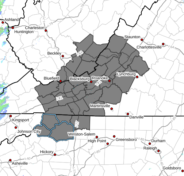
Ashe-Alleghany NC-Surry-Watauga-Wilkes-Tazewell-Smyth-Bland-Giles-
Wythe-Pulaski-Montgomery-Grayson-Carroll-Floyd-Craig-Alleghany VA-
Bath-Roanoke-Botetourt-Rockbridge-Patrick-Franklin-Bedford-
Amherst-Mercer-Summers-Monroe-Eastern Greenbrier-Western
Greenbrier-
Including the cities of Amherst, Sparta, West Jefferson,
Tazewell, Blacksburg, New Castle, Alderson, Duo, Flat Top,
Radford, Pulaski, Hix, Whitetop, Hinton, Galax, Union, Floyd,
Troutdale, Bedford, Quinwood, Bland, Independence, Wytheville,
Stuart, Lewisburg, Volney, Marion, Boone, Clifton Forge,
Rainelle, Fincastle, White Sulphur Springs, Salem, Pearisburg,
Roanoke, Dobson, Buena Vista, Hot Springs, Covington, Bluefield,
Wilkesboro, Rocky Mount, and Lexington
218 AM EDT Thu Mar 20 2025
…WIND ADVISORY IN EFFECT FROM 8 PM THIS EVENING TO 8 AM EDT
FRIDAY…
- WHAT…Northwest winds 20 to 25 mph with gusts up to 50 mph
expected. - WHERE…Portions of north central and northwest North Carolina,
central, south central, southwest, and west central Virginia, and
southeast West Virginia. - WHEN…From 8 PM this evening to 8 AM EDT Friday.
- IMPACTS…Gusty winds will blow around unsecured objects. Tree
limbs could be blown down and a few power outages may result.
PRECAUTIONARY/PREPAREDNESS ACTIONS…
Winds this strong can make driving difficult, especially for high
profile vehicles. Use extra caution.
Secure outdoor objects.