Last Updated on February 17, 2023 9:18 am
Information provided by North Carolina Forest Service. For an update on the Ashe County fire see this link.
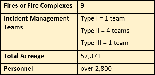
CURRENT SITUATION FOR WESTERN NORTH CAROLINA
Due to the sheer number of uncontained and uncontrolled fires in the southern region, local, state and federal agencies have banded together in an unprecedented effort to contain and control these fires and to help communities prevent new fires from sprouting.
Pervasively dry weather across much of the southeastern U.S. has created perfect conditions for wildfires. Suppression activities throughout the region have stretched resources extremely thin, thus prompting the Southern Area Coordination Center to declare the region under Preparedness Level 5, the highest level, which is rare for the Southern Area. The last time this occurred was in 2007.
AIR QUALITY INFORMATION
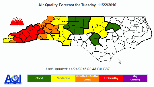
Smoke from numerous wildfires will bring Code Orange to localized Code Red air quality to western North Carolina
Today's Air Quality Conditions:
Localized Code Orange conditions are likely being observed near to or downwind of the Clear Creek fire in McDowell County and possibly near a small wildfire in Ashe County as well. Code Green and localized Code Yellow conditions are otherwise being observed over the rest of the state. For a display of the most recent air quality conditions throughout the remainder of this afternoon, please visit the US EPA's AIRNOW website
Forecast for Tuesday:
High pressure will move into the Carolinas tomorrow, keeping sunny, cool, and dry conditions overhead. Additionally, low-level winds–which have been blowing from the northwest in recent days– will become light and variable tonight and then steady out of the south and southwest as tomorrow progresses. Because of this shift in winds, smoke from the Clear Creek fire in McDowell County, the Pinnacle fire in far-upstate South Carolina, and the Rock Ridge fire on the North Carolina/Georgia state line will begin to drift towards the north and northeast as tomorrow progresses. Code Red conditions, indicating unhealthy air quality for everyone, will be possible tomorrow near and downwind of these fires. This includes the Asheville forecast region as well as Macon and McDowell counties. Within the Asheville forecast region, the main Code Red concerns will be over the southern and central portions of the region including Transylvania, Henderson, Jackson and possibly Haywood and Buncombe counties; Code Orange conditions will be likely over the remainder of the region. Code Orange conditions will be possible over the Hickory forecast region, as well as for a number of counties along the North Carolina Mountains, with Code Yellow conditions possible over Cherokee and Graham counties, the northern Foothills and over the northern/western portions of the Charlotte forecast region (i.e., Iredell, Lincoln and Gaston counties). Elsewhere, Code Green to low-end Code Yellow conditions are expected over the rest of the state.
BURNING RESTRICTIONS
A North Carolina Forest Service ban on all open burning has expanded with the addition of 22 counties for a total of 47 counties, which includes: Alexander, Alleghany, Anson, Ashe, Avery, Buncombe, Burke, Cabarrus, Caldwell, Caswell, Catawba, Cherokee, Clay, Cleveland, Davidson, Davie, Forsyth, Gaston, Graham, Guilford, Haywood, Henderson, Iredell, Jackson, Lincoln, Macon, Madison, McDowell, Mecklenburg, Mitchell, Montgomery, Polk, Randolph, Richmond, Rockingham, Rowan, Rutherford, Stanly, Stokes, Surry, Swain, Transylvania, Union, Watauga, Wilkes, Yadkin and Yancey.
This ban on open burning for the newly added counties is effective at 5 p.m. on November 21, 2016, and shall remain in effect until further notice. The ban on open burning for the previous counties went into effect at 5 p.m. on November 7, 2016, and remains in effect until further notice. Under North Carolina law, the ban prohibits all open burning in the affected counties, regardless of whether a permit was issued. The issuance of any new permits also has been suspended until the ban is lifted. For the list of current closures go to http://ncforestservice.gov/.
A total fire ban is in effect for all lands in the Nantahala and Pisgah National Forests; however, commercially available heating equipment, portable lanterns, or stoves that use gas or pressurized liquid fuel are allowed. More information is at www.fs.usda.gov/detail/nfsnc/alerts-notices/?cid=fseprd524246.
DRONES NOT ALLOWED
Unmanned Aircraft Systems, a.k.a. “drones,” should never be flown over or near a wildfire. Unauthorized drone flights over or near a wildfire could cause serious injury or death to firefighters in the air and/or firefighters and members of the public on the ground. Firefighting aircraft – such as air attack aircraft, lead planes, airtankers and helicopters – typically fly in smoky, windy and turbulent conditions. Safety depends on knowing what other aircraft are operating in the airspace and where they are at all times… If drones fly, critical air support over wildfires cannot.
Arson Reporting
North Carolina is offering a reward of up to $10,000 to be issued to anyone who provides information leading to the arrest and conviction of the person or persons who are responsible for setting wildfires in western North Carolina. Anyone having information concerning these wildfires should contact Macon County Crimestoppers at (828) 349-2600 or Jackson County Crimestoppers at (828) 631-1125.
The Bureau of Indian Affairs is seeking information regarding arson fires on Indian Lands of North Carolina through the WeTip Program. Up to $10,000 is being offered through this anonymous program. WeTip can be contacted through their website: www.wetip.com or by calling their hotline at (800) 47-ARSON ((800) 472-7766).
EVACUATIONS AND CLOSURES
For current information on NCDOT closures please visit: https://tims.ncdot.gov/TIMS/
ROCK MOUNTAIN FIRE Pre-evacuations and Evacuations: Pre-evacuation notices have been issued for Patterson Gap north of Camp Ramah Darom and all roads off Betty's Creek north of Tom Wilson to the North Carolina state line. An evacuation notice is in effect for residents in the Dream Catcher Cove Area, north of Tate City, GA. Towns County (Georgia) and Clay County (North Carolina) have declared a state of emergency. For information on how to prepare for an evacuation, visit http://www.wildlandfirersg.org/.
NANTAHALA NATIONAL FOREST CLOSURES
Major closures on the Nantahala include:
Southern Nantahala Wilderness (North Carolina)
Nantahala National Forest lands east of Eagle Fork community to Southern Nantahala Wilderness boundary
Nantahala National Forest lands south of US 64 and Allison Creek Road (SR 1448), to the Southern Nantahala Wilderness boundary (including the Standing Indian and Hurricane Creek areas)
Nantahala National Forest lands west of the Nantahala Mountains ridge from Mooney Gap to Wallace Gap, and west to the Southern Nantahala Wilderness boundary (including the Appalachian Trail, side trails, and shelter sites)
Nantahala National Forest lands north of US64 and east of State Road 1330 to Nantahala Ranger District boundary
Nantahala National Forest lands south and east of State Road 1307 from State Road 1330 to US64 and the Nantahala Ranger District Boundary
Joyce Kilmer Slickrock Wilderness
Wesser Creek Trail
Chunky Gal Trail
Whitewater Falls Trail and portions of Foothills Trail
Benton MacKaye Trail east of Beech Gap
Appalachian Trail is closed from Dicks Creek Gap/U.S. 76 in Georgia (mile 69.9) to the Nantahala River/US19/US74 in North Carolina (mile 137.1).
Call the US Forest Service office for more information on road and trail closures: 828-257-4200
TODAY'S UPDATES ON ACTIVE FIRES OR FIRE COMPLEXES
For more information visit: http://inciweb.nwcg.gov/state/34/
CLEAR CREEK FIRE (NCFS / USFS – PLEASANT GARDENS AREA, MCDOWELL COUNTY)
At the time of this summary, the Clear Creek Fire is being transitioned to the Eastern Montana IMT Type 2 Team. The team will assume incident management this evening at 8 P.M. Clear Creek Road is closed to the public allowing fire personnel and equipment to safely enter the area. Residents living on Clear Creek Road are allowed entry, but asked to limit travel. No evacuations have been necessary thus far; however, there is a public meeting scheduled for Tuesday 11/22/16. The location and time is to be determined. Updated information will be posted on the 11/22/16 Morning Summary.
Acreage: 186 – Start Date: November 20
MAPLE SPRINGS FIRE (USFS-LAKE SANTEELAH AREA, GRAHAM COUNTY)
Increased containment was gained on the northwest perimeter of the fire and extends south to the Joyce Kilmer-Slickrock Wilderness boundary. Minimal fire spread is expected on the Maple Springs fire based on the success of suppression actions and the forecasted weather. An infrared flight Sunday night revealed only about a half dozen heat spots remaining on the fire and all the heat signatures were well within containment lines.
Firefighters are mopping up and patrolling fire lines while initiating rehabilitation measures on dozer lines, helispot bases and other areas of the fire where suppression actions disturbed the landscape. A fireline explosive crew finished blasting operations in the Memorial Forest on Sunday but will be taking a few more hazard trees down today along Forest Road 416 leading into the Joyce Kilmer Memorial Forest. A U.S. Forest Service closure order remains in place for the Joyce Kilmer-Slickrock Wilderness and roads leading into the area.
Acreage: 7,788 – Containment: 69% – Personnel: 300 – Start Date: November 4
http://inciweb.nwcg.gov/incident/5090/
Tellico Fire (USFS-NANTAHALA GORGE AREA, Swain and Macon Counties)
Yesterday's red-flag fire-weather warning put firefighters on high alert. Infrared flight data revealed isolated areas of heat along the north and south perimeter of the fire. Seasonal leaf fall continues to blanket the area with dried leaves. This fuel bed had the potential for active fire behavior, but that did not occur. Only minimal creeping and smoldering fire behavior was observed. No structures are imminently threated, but the proximity of the fireline to residential areas makes monitoring and patrolling a high priority. Firefighters will strengthen containment lines and work to ensure the fire does not escape its boundaries.
Acreage: 13,874 – Containment: 91% – Personnel: 294 – Start Date: November 3
http://inciweb.nwcg.gov/incident/5084/
Boteler Fire (USFS-CHUNKY GAL AREA, Clay County)
Due to continued leaf fall and gusty winds, firefighters will continue to monitor hotspots and strengthen the fireline in the area of Vineyard Road. In the northeast corner of the fire, firefighters continue to strengthen firelines in steep terrain off Thunderstruck Road near Tate Gap. Interior areas of the fire continue to reburn due to leaf fall. Today, firefighters will continue to monitor and respond to any threats to the containment line. Leaf fall continues to challenge containment efforts by covering firelines, causing reburn. Planned actions include patrolling and monitoring existing fire lines. Hotspots detected by infrared flights east of East Vineyard will be closely monitored. Firefighters are prepared to respond to any new fires in the area.
Acreage: 9,039 acres – Containment: 77% – Personnel: 391 – Start Date: October 25
http://inciweb.nwcg.gov/incident/5075/
CATHY GAP FIRE (USFS – JACKSON/TRANSYLVANIA COUNTY LINE)
Despite higher winds and very low relative humidity, only moderate creeping and smoldering fire behavior was observed on Sunday. A warming trend is predicted for the coming days. Forecasters are calling for temperatures in the 50s on Monday, and into the 60s on Tuesday. Higher temperatures combined with low relative humidity have the potential to encourage more active fire behavior. Seasonal leaf fall continues to be a concern due to reburn potential. Large volumes of dried leaves are falling into the fire area and onto containment lines. The Cathy Gap Fire is being managed using a combination of point protection, indirect and direct control lines, and containment strategies based on the values and principals of the Forest Service “Life First” policy. Using Life First principals, tactical decisions are evaluated on the probability of success and best risk management policies, putting the safety of firefighters first.
Acreage: 123 – Containment: 90% – Personnel: 57- Start Date: November 1
http://inciweb.nwcg.gov/incident/5105/
PARTY ROCK FIRE (NCFS-LAKE LURE AREA, RUTHERFORD, BUNCOMBE, AND HENDERSON COUNTIES)
All evacuation and pre-evacuation notices for the Town of Lake Lure and surrounding neighborhoods were cancelled as of noon today, Monday 11/21/16. This included those parts of the Rumbling Bald Resort that have been under a mandatory evacuation notice: Deerfield, Fairfield, Youngs Mountain and Quail Ridge. The pre-evacuation notice for Three Creeks, Cedar Creek Road, Buffalo Creek Road, Riverbend Highlands, Tatanka, Apple Valley, Shumont Estates and Buffalo Shoals, was also cancelled as of noon today. A state of emergency remains in effect for the town of Lake Lure.
Acreage: 7,171 – Containment: 45% – Personnel: 925 – Start Date: November 5
http://inciweb.nwcg.gov/incident/5092/#
CHESTNUT KNOB FIRE (NCFS-SOUTH MOUNTAINS STATE PARK, BURKE COUNTY)
Falling leaves are producing “re-burn” in previously burned areas as they fall into smoldering areas and ignite. The falling leaves are also covering fire lines, which is requiring crews to clean out fire lines several times daily. Fire crews will continue to mop up and hold the fire line in all divisions.
Acreage: 6,435- Containment: 50% – Personnel: 395 – Start Date: November 6
http://inciweb.nwcg.gov/incident/5101/
DOBSON 3 FIRE (BIA-QUALLA BOUNDARY, JACKSON COUNTY)
P.M. update remains unchanged; resources continue to be available to assist local resources with any new fires that may start within the Qualla Boundary. Fire suppression crews continue to monitor and patrol all fires within the Qualla Boundary. Safety of the firefighters and the community is number the one priority as the firefighters go about their daily responsibilities.
Acreage: 756- Containment: 85% – Personnel: 80 – Start Date: November 2
http://inciweb.nwcg.gov/incident/5097/#
ROCK MOUNTAIN FIRE (USFS – SOUTHERN NANTAHALA WILDERNESS AREA, NORTH GEORGIA AND CLAY AND MACON COUNTIES IN NC)
Firefighters will patrol and re-clear existing containment lines on the south fire perimeter, and additional crews have been assigned to the east fire perimeter. On the northern fire perimeter, line construction and scouting will continue and as conditions allow. A public meeting is being held tonight 6 P.M. at the Rabun County Courthouse in Clayton, GA.
Acreage: 12,779- Containment: 30% – Personnel: 434- Start Date: November 9
http://inciweb.nwcg.gov/incident/5100/#


