Last Updated on November 19, 2016 9:44 pm
Information provided by the North Carolina Forest Service. As a side note, Watauga Online continues to get questions about wildfires in Watauga, Ashe or Avery counties. To date there have been no wildfires associated with the outbreak to our south.
CURRENT SITUATION
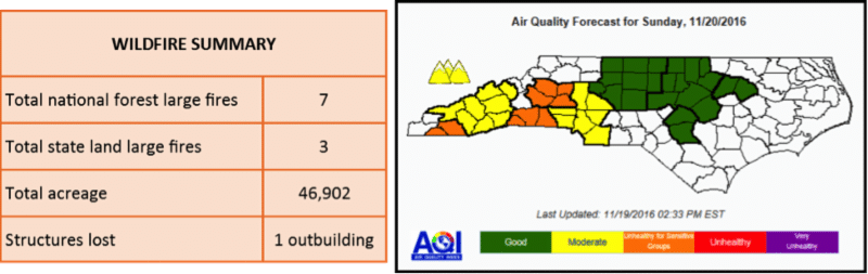
Despite warm, dry conditions yesterday, there was little growth on area fires. Total large fire acreage today is at 46,902 acres, an increase of 930 acres from yesterday. A red flag warning is in effect until midnight tonight for increased fire danger across the NC Mountains and foothills. Some areas received trace amounts of rain this morning, but high winds quickly dried fuels. Western NC is experiencing sustained winder of 10-15 mph and gusts up to 40 mph this afternoon. Windy conditions are expected to continue through tomorrow afternoon. Fire crews are monitoring containment lines during the wind event. Re-burn is a concern on all fires as new fuels (dried leaves, branches, etc.) fall onto hot spots.
AIR QUALITY INFORMATION
The response of ongoing fires to this new weather system is difficult to predict, so out of caution a Code Orange forecast has been issued for the Hickory forecast region, as well as for Cleveland, Polk, Rutherford, Macon, and Clay counties tomorrow, due to these areas' proximity to ongoing fires. Members of sensitive groups may experience health effects. The general public is not likely to be affected.
Code Yellow conditions are currently expected in the Asheville and Charlotte forecast regions, but this forecast may be subject to change Sunday morning if observations show that smoky conditions are building back in to these regions. Unusually sensitive people should consider limiting prolonged or heavy exertion outdoors.
BURNING RESTRICTIONS
A total fire ban is in effect for all lands in the Nantahala and Pisgah National Forests; however, commercially available heating equipment, portable lanterns, or stoves that use gas or pressurized liquid fuel are allowed. More information is at www.fs.usda.gov/detail/nfsnc/alerts-notices/?cid=fseprd524246
The North Carolina Forest Service continues its ban on open burning in 25 western counties in North Carolina. Under North Carolina law, the ban prohibits all open burning in the affected counties, regardless of whether a permit was issued. The issuance of any new permits also has been suspended until the ban is lifted.
HUNTER INFORMATION
Rifle hunting season begins Monday in Western NC. For those hunting in the National Forests, many areas have temporary Forest closures. Contact your local ranger district to find specific information about closures, as closures may not be clear if traveling off roads and trails. To ensure your safety and the safety of our firefighters, please observe all closures and fire restrictions. For updated hunting closure information visit http://www.ncwildlife.org/Hunting/Where-to-Hunt/Public-Places
TODAYS UPDATES ON MAJOR AREA FIRES
For more information visit: http://inciweb.nwcg.gov/state/34/
MAPLE SPRINGS FIRE (USFS-LAKE SANTEELAH AREA, GRAHAM COUNTY)
On Friday, helicopters dropped approximately 67,000 gallons of water along the southern and western flanks of the fire to address hot spots identified by an infrared (IR) flight. All the hot spots pinpointed by the IR flights are well inside perimeter lines. Work on both fires now consists primarily of patrolling and mopping up containment lines. Firefighters are contending with a drastic change in weather today as a cold front moves into the area.
Acreage: 7,788 – Containment: 51% – Personnel: 340 – Start Date: November 4
Tellico Fire (USFS-NANTAHALA GORGE AREA, Swain and Macon Counties)
High winds today and tomorrow may intensify fire spread. Leaf fall will also increase and re-burn will be possible where leaves and smoldering fire meet. Fuel moisture levels at historic lows combined with predicted high winds make extreme fire behavior possible today. Spread rates will be highest along ridges and exposed areas. Extended burn periods are possible with no breaks in wind and modest humidity recovery.
Acreage: 13,874 – Containment: 88% – Personnel: 464 – Start Date: November 3
Boteler Fire (USFS-CHUNKY GAL AREA, Clay County)
Today, firefighters will patrol and monitor existing fire lines as continued leaf fall is causing problems by covering control lines and increasing re-burn potential. Hot spots detected by infrared over flights east of East Vineyard and will be closely monitored. Two initial attack groups will be prepared to respond to any new fires in the area.
Acreage: 9,015 – Containment: 72% – Personnel: 390 – Start Date: October 25
CATHY GAP FIRE (USFS – JACKSON/TRANSYLVANIA COUNTY LINE)
Crews continue to work to contain and suppress the Cathy Gap Fire. Fire lines are being strengthened and crews will monitor the fire to ensure that any flare-ups do not escape the fire line. A substantial number of firefighters and equipment have been assigned to the fire and still more are in staging, ready to respond should they be needed.
Acreage: 123 – Containment: 80% – Personnel: 71 – Start Date: November 17
PARTY ROCK FIRE (NCFS-LAKE LURE AREA, RUTHERFORD, BUNCOMBE, AND HENDERSON COUNTIES)
Firefighters are prepared for this weekend's wind event. Today 2 light & 1 medium helicopter will support fire operations; air tankers will be used to reinforce contingency lines with retardant during the morning. The West and East sides of fire have been secured and firefighters will patrol these lines through the weekend.
Acreage: 7,171- Containment: 36% – Personnel: 920 – Start Date: November 5
CHESTNUT KNOB FIRE (NCFS-SOUTH MOUNTAINS STATE PARK, BURKE COUNTY)
In preparation for today's weather, burnout operations were completed yesterday near containment lines. Structure protection groups used leaf blowers and rakes to remove leaf litter around homes near the fire area.
Acreage: 6,340 – Containment: 35% – Personnel: 325 – Start Date: November 6
DOBSON 3 FIRE (BIA – QUALLA BOUNDARY, JACKSON COUNTY)
Fire Fighters will be monitoring the fire for any activity. We are asking everyone to stay diligent in helping prevent wild fires.
Acreage: 756 acres – Containment: 85% – Personnel: 80 – Start Date: November 2
ROCK MOUNTAIN FIRE (USFS – SOUTHERN NANTAHALA WILDERNESS IN GA AND NC)
Predicted winds will test firelines today and if new fires start they have the potential for rapid spread. In response, additional resources have been assigned to provide initial attack response and the public is reminded of the importance of extreme caution with anything that could lead to a new fire start. Firefighters will patrol and re-clear existing containment lines on the east, west and south fire perimeter. The wind increases the potential for burning leaves to move outside containment lines.
Acreage: 9,382 – Containment: 30% – Personnel: 482 – Start Date: November 9
- Southern Nantahala Wilderness (North Carolina)
- Nantahala National Forest lands east of Eagle Fork community to Southern Nantahala Wilderness boundary
- Nantahala National Forest lands south of US 64 and Allison Creek Road (SR 1448), to the Southern Nantahala Wilderness boundary (including the Standing Indian and Hurricane Creek areas)
- Nantahala National Forest lands west of the Nantahala Mountains ridge from Mooney Gap to Wallace Gap, and west to the Southern Nantahala Wilderness boundary (including the Appalachian Trail, side trails, and shelter sites)
- Nantahala National Forest lands north of US64 and east of State Road 1330 to Nantahala Ranger District boundary
- Nantahala National Forest lands south and east of State Road 1307 from State Road 1330 to US64 and the Nantahala Ranger District Boundary
- Joyce Kilmer Slickrock Wilderness
- Wesser Creek Trail
- Chunky Gal Trail
- Whitewater Falls Trail and portions of Foothills Trail
- Benton MacKaye Trail east of Beech Gap
- Appalachian Trail in Nantahala National Forest