Last Updated on July 23, 2024 1:28 pm
NCZ001>006-018>020-VAZ007-009>020-022>024-032>035-043>047-058-059-
WVZ042>044-507-508-231830-
Ashe-Alleghany NC-Surry-Stokes-Rockingham-Caswell-Watauga-Wilkes-
Yadkin-Tazewell-Smyth-Bland-Giles-Wythe-Pulaski-Montgomery-
Grayson-Carroll-Floyd-Craig-Alleghany VA-Bath-Roanoke-Botetourt-
Rockbridge-Patrick-Franklin-Bedford-Amherst-Henry-Pittsylvania-
Campbell-Appomattox-Buckingham-Halifax-Charlotte-Mercer-Summers-
Monroe-Eastern Greenbrier-Western Greenbrier-
Including the cities of West Jefferson, Sparta, Dobson, Danbury,
Eden, Yanceyville, Boone, Wilkesboro, Yadkinville, Tazewell,
Marion, Bland, Pearisburg, Wytheville, Radford, Pulaski,
Blacksburg, Independence, Whitetop, Troutdale, Volney, Galax,
Floyd, New Castle, Clifton Forge, Covington, Hot Springs,
Roanoke, Salem, Fincastle, Lexington, Buena Vista, Stuart,
Rocky Mount, Bedford, Amherst, Martinsville, Danville, Lynchburg,
Appomattox, South Boston, Keysville, Bluefield, Flat Top, Hinton,
Hix, Union, Lewisburg, White Sulphur Springs, Alderson, Quinwood,
Duo, and Rainelle
118 PM EDT Tue Jul 23 2024
…Thunderstorms With Heavy Rain…
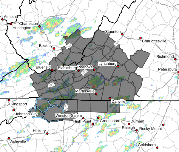
At 115 PM…National Weather Service radar indicated the development of scattered showers and thunderstorms throughout the region.
These showers and storms are expected to become more numerous through the afternoon.
The main hazard is heavy rain, with rainfall rates of up to 3 inches an hour being observed. This will result in rainfall of up to one inch in 20 minutes, causing flooding of poor drainage areas and ponding of water on roads.
Some of the stronger storms may contain wind gusts of 30 to 40 mph which may cause isolate wind damage and power outages.