![](https://wataugaonline.com/wp-content/uploads/2020/04/collage-severe-weather-Easter-Sunday-2020.png)
Last Updated on February 12, 2022 6:44 pm
UPDATE – Sunday afternoon 5:23pm
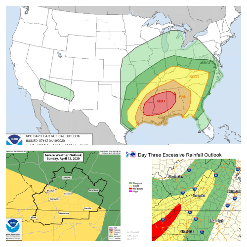
UPDATE – Easter Sunday morning. Graphics courtesy of NWS.
A Flash Flood Watch is in effect from this evening through Monday morning. Learn more by clicking here.
![](https://c5f6d7b8.stackpathcdn.com/wp-content/uploads/2020/04/NWS-Sunday-April-12-1-800x600.jpg)
![](https://wataugaonline.com/wp-content/uploads/2020/04/NWS-Sunday-April-12-2-800x600.jpg)
![](https://wataugaonline.com/wp-content/uploads/2020/04/NWS-Sunday-April-12-3-800x600.jpg)
![](https://wataugaonline.com/wp-content/uploads/2020/04/NWS-Sunday-April-12-4-800x600.jpg)
![](https://wataugaonline.com/wp-content/uploads/2020/04/NWS-Sunday-April-12-5.png)
UPDATE – Saturday morning
Severe weather is likely for Easter Sunday, which could lead to flooding and very high winds.
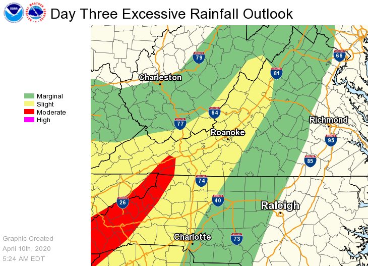
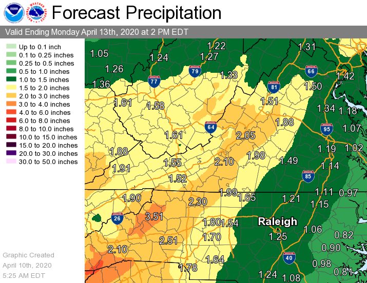
Rainfall rates of 3 to 4 inches in 24 hours are possible which could lead to a Flood Watch, according to the National Weather Service (NWS).
The other major weather story will be very strong winds. A High Wind Warning may be issued, NWS states. The criteria for a High Wind Warning is sustained winds 40 mph or greater, for better than 1 hour – and/or wind gusts 58 mph or greater, for any duration.
Check back here for more information as WataugaOnline.com will be updating this unfolding situation throughout the weekend.
Graphics courtesy of NOAA/NWS
![](https://wataugaonline.com/wp-content/uploads/2020/04/Severe-Weather-Outlook-for-Sunday-April-12-2020-800x601-1.jpg)
![](https://wataugaonline.com/wp-content/uploads/2020/04/Excessive-rainfall-outlook.jpg)
![](https://wataugaonline.com/wp-content/uploads/2020/04/Forecast-rainfall-through-Monday-April-13-2020.jpg)
![](https://wataugaonline.com/wp-content/uploads/2020/04/Sunday-April-12-outlook-day3otlk_0730-800x545.jpg)