Last Updated on July 30, 2024 6:34 am
NCZ060-061-TNZ012>018-035>047-067>074-081>087-098>102-VAZ001-002-005-
006-008-302100-
/O.NEW.KMRX.FA.A.0006.240730T0736Z-240731T0900Z/
/00000.0.ER.000000T0000Z.000000T0000Z.000000T0000Z.OO/
Cherokee-Clay-Scott TN-Campbell-Claiborne-Hancock-Hawkins-
Sullivan-Johnson-Morgan-Anderson-Union-Grainger-Hamblen-Northwest
Cocke-Cocke Smoky Mountains-Northwest Greene-Southeast Greene-
Washington TN-Unicoi-Northwest Carter-Southeast Carter-Roane-
Loudon-Knox-Jefferson-Northwest Blount-Blount Smoky Mountains-
North Sevier-Sevier Smoky Mountains-Sequatchie-Bledsoe-Rhea-Meigs-
McMinn-Northwest Monroe-Southeast Monroe-Marion-Hamilton-Bradley-
West Polk-East Polk-Lee-Wise-Scott VA-Russell-Washington VA-
Including the cities of Bristol VA, Dayton, Seymour, Greeneville,
Doeville, Pigeon Forge, South Pittsburg, Marble, Honaker, Martin
Springs, Pardee, Coeburn, Murphy, Kodak, La Follette, Parksville,
Shady Valley, Dye, Laurel Bloomery, Oliver Springs, Lone
Mountain, Harrisburg, Royal Blue, Benhams, High Point, Alcoa, Big
Stone Gap, Powells Crossroads, Monteagle, Bradbury, Bristol TN,
Chestnut Hill, Clear Water, Clairfield, Lone Oak, Bybee,
Evensville, Bean Station, Dentville, Elk Valley, Archville,
Shooting Creek, Maryville, Lenoir City, South Holston Dam,
Newport, Violet, Palio, Slick Rock, Norton, Sharps Chapel,
Dandridge, Sweetwater, Mooresburg, Caryville, Tusquitee, Oak
Ridge, Loudon, Elizabethton, Old Cumberland, Pikeville, Howard
Quarter, McMahan, Kingston, Gatlinburg, Strawberry Plains,
Brayton, Madisonville, Huntsville, Turtletown, Big South Fork
National, Andrews, Hartford, Knoxville, Mountain City, Etowah,
White Pine, Elkmont, Appalachia, Abingdon, Evanston, Fairview,
Bullet Creek, Hansonville, Russellville, Elgin, Norris Lake,
Whitwell, Eagle Furnace, Cartwright, Cades Cove, Fincastle,
Norma, Arthur, Kyles Ford, Johnson City, Big Frog Mountain,
Rockwood, Chattanooga, Alpha, Signal Mountain, Spring City,
Springdale, Topton, Jefferson City, Coker Creek, Wise, Rose Hill,
Treadway, Luttrell, Grandview, Limestone Cove,
Harrogate-Shawanee, Old Washington, Oneida, Hiawasse Dam, Citico,
Hiltons, Lebanon, Ducktown, Sandlick, Unaka, Lake Forest, Cagle,
Happy Valley, Tasso, Unicoi, Castlewood, Athens, Conasauga,
Brasstown, Jellico, Paulette, Hayesville, Mount Crest, Cleveland,
Rosedale, Sneedville, Neva, Hampton, Dunlap, Melvine, Big Spring,
Benton, Cedar Creek, Sevierville, Morristown, Clinton, Lookout
Mountain, Kingsport, Pine Orchard, Maynardville, Petros,
Reliance, Trade, Haletown (Guild), White Oak, Smokey Junction,
Bearden, Erwin, Jasper, and Harriman
336 AM EDT Tue Jul 30 2024 /236 AM CDT Tue Jul 30 2024/
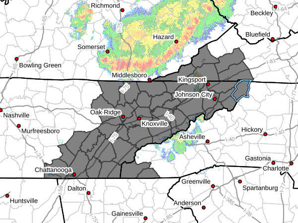
…FLOOD WATCH IN EFFECT THROUGH LATE TONIGHT…
- WHAT…Flash flooding caused by excessive rainfall is possible.
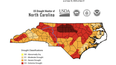
- WHERE…Portions of southwest North Carolina, including the
following areas, Cherokee and Clay, east Tennessee, including the
following areas, Anderson, Bledsoe, Blount Smoky Mountains,
Bradley, Campbell, Claiborne, Cocke Smoky Mountains, East Polk,
Grainger, Hamblen, Hamilton, Hancock, Hawkins, Jefferson, Johnson,
Knox, Loudon, Marion, McMinn, Meigs, Morgan, North Sevier,
Northwest Blount, Northwest Carter, Northwest Cocke, Northwest
Greene, Northwest Monroe, Rhea, Roane, Scott TN, Sequatchie,
Sevier Smoky Mountains, Southeast Carter, Southeast Greene,
Southeast Monroe, Sullivan, Unicoi, Union, Washington TN and West
Polk, and southwest Virginia, including the following areas, Lee,
Russell, Scott VA, Washington VA and Wise. - WHEN…Through late tonight.
- IMPACTS…Excessive runoff may result in flooding of rivers,
creeks, streams, and other low-lying and flood-prone locations.
Creeks and streams may rise out of their banks. Low-water
crossings may be flooded. - ADDITIONAL DETAILS…
- Over the past 24 to 48 hours, many locations have received 2
to 3 inches or more of rainfall. From this morning through
tonight, multiple rounds of storms are expected with many
locations likely to receive another 1 to 2 inches. Locally
higher amounts are possible. - http://www.weather.gov/safety/flood
PRECAUTIONARY/PREPAREDNESS ACTIONS…
You should monitor later forecasts and be prepared to take action
should Flash Flood Warnings be issued.