


Last Updated on May 26, 2022 5:48 am
GAZ010-017-NCZ033-048>053-058-059-062>065-501>510-SCZ101>103-261615-
/O.NEW.KGSP.FA.A.0002.220526T0807Z-220527T1600Z/
/00000.0.ER.000000T0000Z.000000T0000Z.000000T0000Z.OO/
Rabun-Habersham-Avery-Madison-Yancey-Mitchell-Swain-Haywood-Buncombe-
Graham-Northern Jackson-Macon-Southern Jackson-Transylvania-
Henderson-Caldwell Mountains-Greater Caldwell-Burke Mountains-
Greater Burke-McDowell Mountains-Eastern McDowell-Rutherford
Mountains-Greater Rutherford-Polk Mountains-Eastern Polk-Oconee
Mountains-Pickens Mountains-Greenville Mountains-
Including the cities of Cullowhee, Lenoir, Mill Spring, Glassy
Mountain, Spruce Pine, Marion, Almond, Valdese, Granite Falls, Fero,
Hot Springs, Tuxedo, Old Fort, Stecoah, Ingalls, Cruso, Little
River, Hendersonville, Rainbow Springs, Canton, Kings Creek,
Columbus, Allenstand, Saluda, Fletcher, Rutherfordton, Asheville,
Sylva, Etowah, Wesser, Mountain City, Sugar Hill, Micaville,
Baldwin, Patterson, Pine Mountain, Alarka, Forest City, East Flat
Rock, Luada, Robbinsville, Sawmills, Jonas Ridge, Marshall, Wolf
Mountain, Waterville, Woodlawn, Ashford, Glenwood, Kyle, Brevard,
Mars Hill, Franklin, Spindale, Luck, Clarkesville, Dysartsville,
Black Mountain, Waynesville, Tryon, Morganton, Celo, Nebo, Bryson
City, Ramseytown, Highlands, Walnut, Cove Creek, Dana, Pleasant
Grove, Mountain Rest, Poplar, Rocky Bottom, Faust, Demorest, Cedar
Mountain, Chimney Rock State Park, Swiss, Clayton, Cashiers,
Burnsville, Tuckasegee, Hollywood, Newland, Candler, Busick,
Cornelia, and Banner Elk
407 AM EDT Thu May 26 2022
…FLOOD WATCH IN EFFECT THROUGH FRIDAY MORNING…
- WHAT…Flash flooding caused by excessive rainfall is possible.
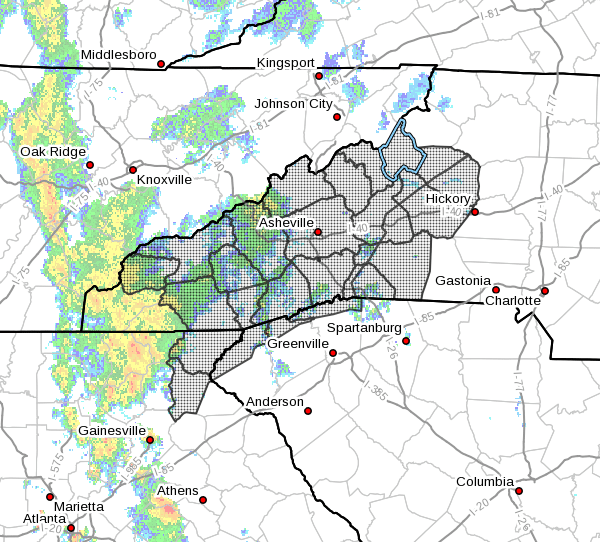
- WHERE…Portions of northeast Georgia, western North Carolina and
upstate South Carolina, including the following areas, in
northeast Georgia, Habersham and Rabun. In western North Carolina,
Avery, Buncombe, Burke Mountains, Caldwell Mountains, Eastern
McDowell, Eastern Polk, Graham, Greater Burke, Greater Caldwell,
Greater Rutherford, Haywood, Henderson, Macon, Madison, McDowell
Mountains, Mitchell, Northern Jackson, Polk Mountains, Rutherford
Mountains, Southern Jackson, Swain, Transylvania and Yancey. In
upstate South Carolina, Greenville Mountains, Oconee Mountains and
Pickens Mountains. - WHEN…Through Friday morning.
- IMPACTS…Excessive runoff may result in flooding of rivers,
creeks, streams, and other low-lying and flood-prone locations. - ADDITIONAL DETAILS…
- Widespread rain with embedded thunderstorms will affect the
mountains and foothills today and tonight with rainfall
amounts of 2 to 4 inches in the southerly upslope areas. Some
locations could receive up to five inches of rain. Lesser
amounts are expected along the Tennessee border. Although it
had been relatively dry this month, rainfall over the last
several days has increased the soil moisture and raised the
threat for enough runoff to lead to flash flooding in the
Watch area. - http://www.weather.gov/safety/flood
PRECAUTIONARY/PREPAREDNESS ACTIONS…
Rainfall of more than five inches in similar storms has been
associated with an increased risk of landslides and rockslides. If
you live on a mountainside or in a cove at the base of a mountain,
especially near a stream, be ready to leave in advance of the storm
or as quickly as possible should rising water, moving earth, or
rocks threaten. Consider postponing travel along mountain roads
during periods of heavy rainfall.


