Last Updated on April 16, 2024 2:57 pm
NCC011-170030-
/O.NEW.KGSP.FA.Y.0050.240416T1853Z-240417T0030Z/
/00000.N.ER.000000T0000Z.000000T0000Z.000000T0000Z.OO/
Avery NC-
253 PM EDT Tue Apr 16 2024
…FLOOD ADVISORY IN EFFECT UNTIL 830 PM EDT THIS EVENING…
- WHAT…Flooding caused by excessive rainfall is expected.
- WHERE…A portion of western North Carolina, including the
following county, Avery. - WHEN…Until 830 PM EDT.
- IMPACTS…Nuisance to Minor flooding of low-lying areas adjacent
to streams and other poor-drainage areas, including farmland,
parks, greenways, boat-access areas, golf courses, underpasses,
and parking lots. Isolated, shallow flows over roadways is
possible. A few flood-prone, low-water crossings may become
impassible. A culvert washout is possible. - ADDITIONAL DETAILS…
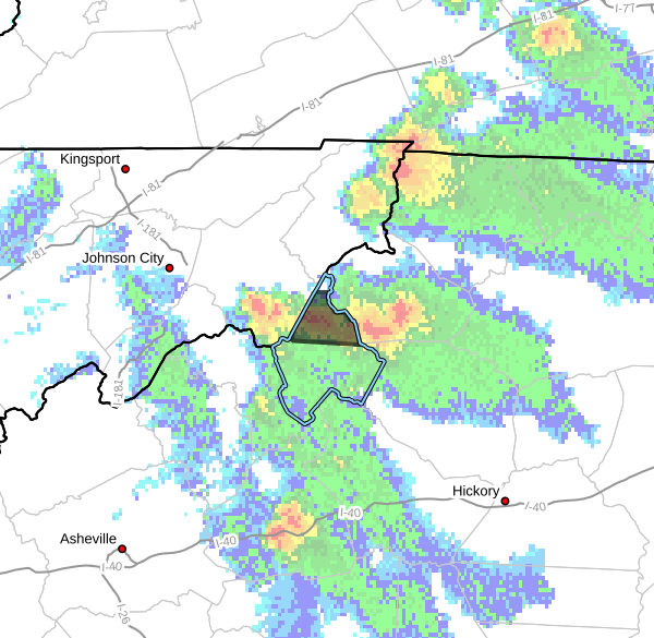
- At 238 PM EDT, Doppler radar indicated heavy rain due to
nearly stationary thunderstorms producing torrential
rainfall. Between 1 and 2 inches of rain have fallen over
the past 75 minutes, which is typically not significant
enough to cause flooding concerns. However, these storms are
persisting across the headwaters of Elk River from Beech
Mountain to Banner Elk to Elk Park and an additional 1-2
inches of rainfall is possible over the next 1-2 hours before
these storms slowly drift to the south and east and
dissipate. This will likely cause some small streams to
quickly reach bankfull with some adjacent lowland flooding
possible, impacting low-water crossings and other flood-prone
areas.
The areas of heaviest rainfall are along and north of a line
from Beech Mountain to Banner Elk to Elk Park including near
Elk River Rd, Banner Elk Hwy (NC 194), and Skalley Branch Ln.
Other areas along the Elk River and feeder streams, including
near Reuben Wooten Rd and Edgar Tufts Rd, may experience
rapid rises over the next few hours as the heavy rainfall
slowly shifts south.
- If storm-total rainfall amounts exceed 3-4 inches over the
next 1-2 hours, more significant flooding may develop and a
Flash Flood Warning may be issued. Caution is advised near
any stream or other vulnerable area. Seek higher ground
immediately if streams start to rise. Please have a plan in
place should flash flooding develop and do not hesitate to
act. - Some locations that may experience flooding include…
Banner Elk and Elk Park - Http://www.weather.gov/safety/flood
PRECAUTIONARY/PREPAREDNESS ACTIONS…
In hilly terrain there are hundreds of low water crossings which are
potentially dangerous in heavy rain. Do not attempt to cross flooded
roads. Find an alternate route.
Flooding is occurring or is imminent. It is important to know where
you are relative to streams, rivers, or creeks which can become
killers in heavy rains. Campers and hikers should avoid streams or
creeks.
&&