Last Updated on August 6, 2022 12:55 pm
NCC005-009-189-VAC077-061945-
/O.NEW.KRNK.FA.Y.0097.220806T1648Z-220806T1945Z/
/00000.N.ER.000000T0000Z.000000T0000Z.000000T0000Z.OO/
Alleghany NC NC-Ashe NC-Watauga NC-Grayson VA-
1248 PM EDT Sat Aug 6 2022
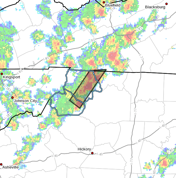
…FLOOD ADVISORY IN EFFECT UNTIL 345 PM EDT THIS AFTERNOON…
- WHAT…Flooding caused by excessive rainfall is expected.
- WHERE…Portions of northwest North Carolina and southwest
Virginia, including the following counties, in northwest North
Carolina, Alleghany NC, Ashe and Watauga. In southwest Virginia,
Grayson. - WHEN…Until 345 PM EDT.
- IMPACTS…Minor flooding in low-lying and poor drainage areas.
Dangerous flows over low-water crossings will be possible. - ADDITIONAL DETAILS…
- At 1248 PM EDT, Doppler radar indicated heavy rain due to
thunderstorms moving slowly across the High Country from near
Deep Gap north to Piney Creek. Minor flooding is ongoing or
expected to begin shortly in the advisory area. - This includes the following streams and drainages…
Elk Creek, Call Creek, Grassy Creek, Beaver Creek, Mulberry
Creek, Dog Creek, Meat Camp Creek, Helton Creek, Left Prong
Stony Fork, Naked Creek, Little Phoenix Creek and Crab Fork. - Some locations that will experience flooding include…
Jefferson… West Jefferson…
Glendale Springs… Deep Gap…
Todd… Mouth Of Wilson…
Mount Jefferson… - http://www.weather.gov/safety/flood
PRECAUTIONARY/PREPAREDNESS ACTIONS…
Be aware of your surroundings and do not drive on flooded roads.
When it is safe to do so, please send your reports of flooding,
including mudslides or flooded roads, to the National Weather
Service by calling toll free at 1…8 6 6…2 1 5…4 3 2 4. Reports
and pictures can also be shared on the National Weather Service
Blacksburg Facebook page and on Twitter.


