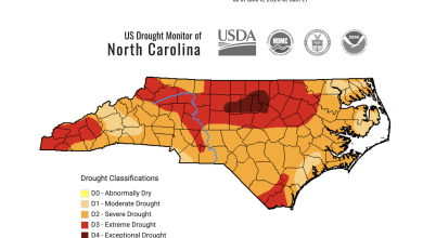
Last Updated on February 18, 2025 8:42 am
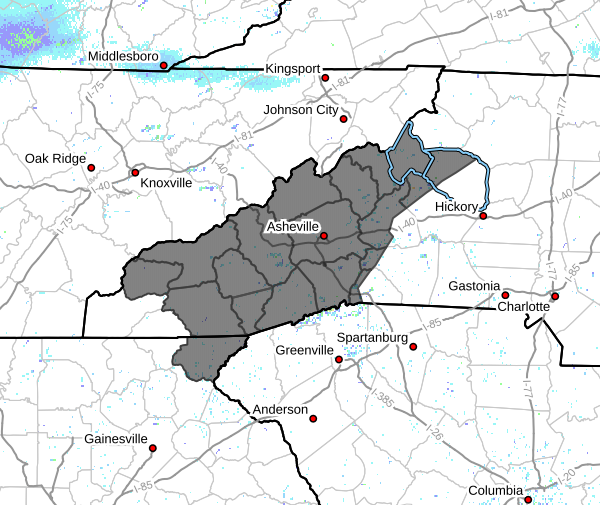
GAZ010-NCZ033-048>053-058-059-062>065-501-503-505-507-509-181700-
/O.NEW.KGSP.WW.Y.0008.250219T1100Z-250220T1700Z/
Rabun-Avery-Madison-Yancey-Mitchell-Swain-Haywood-Buncombe-Graham-
Northern Jackson-Macon-Southern Jackson-Transylvania-Henderson-
Caldwell Mountains-Burke Mountains-McDowell Mountains-Rutherford
Mountains-Polk Mountains-
Including the cities of Franklin, Hot Springs, Burnsville, Mars
Hill, Waterville, Bryson City, Mountain City, Asheville,
Cashiers, Luada, Ramseytown, Busick, Cullowhee, Ingalls, Cove
Creek, Faust, Alarka, Sylva, Chimney Rock State Park, Spruce
Pine, Old Fort, Waynesville, Banner Elk, Tuckasegee, Rainbow
Springs, Etowah, Allenstand, Pine Mountain, Robbinsville, Cruso,
Walnut, Poplar, Woodlawn, Luck, Wesser, East Flat Rock, Black
Mountain, Ashford, Canton, Stecoah, Highlands, Celo, Brevard,
Little River, Dana, Hendersonville, Micaville, Marshall, Jonas
Ridge, Newland, Wolf Mountain, Sugar Hill, Clayton, Swiss,
Patterson, Kyle, Fletcher, Tuxedo, Cedar Mountain, Saluda,
Candler, and Almond
330 AM EST Tue Feb 18 2025
…WINTER WEATHER ADVISORY IN EFFECT FROM 6 AM WEDNESDAY TO NOON EST
THURSDAY…
- WHAT…Mixed precipitation expected. Total snow accumulations up
to 3 inches and ice accumulations around a light glaze. Winds
gusting as high as 40 mph. - WHERE…Portions of northeast Georgia and western North Carolina.
- WHEN…From 6 AM Wednesday to noon EST Thursday.
- IMPACTS…Icing may create slippery conditions on roads, bridges
and sidewalks. The hazardous conditions could impact the Wednesday
morning and evening commutes.
PRECAUTIONARY/PREPAREDNESS ACTIONS…
Slow down and use caution while traveling. The latest road
conditions for the state you are calling from can be obtained by
calling 5 1 1.