Last Updated on February 10, 2025 8:09 am
NCZ001-002-VAZ010>020-022-032-033-WVZ042>044-507-508-102130-
/O.UPG.KRNK.WS.A.0004.250211T0900Z-250212T2100Z/
/O.NEW.KRNK.WS.W.0006.250211T1100Z-250212T1700Z/
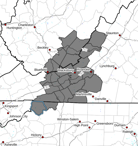
Ashe-Alleghany NC-Bland-Giles-Wythe-Pulaski-Montgomery-Grayson-
Carroll-Floyd-Craig-Alleghany VA-Bath-Roanoke-Patrick-Franklin-
Mercer-Summers-Monroe-Eastern Greenbrier-Western Greenbrier-
Including the cities of Salem, Alderson, New Castle, Covington,
Sparta, Quinwood, Whitetop, Volney, Duo, Lewisburg, Pulaski,
Independence, Hinton, Troutdale, Hix, Rainelle, Bland, Hot
Springs, Flat Top, Galax, Stuart, Union, Radford, Bluefield,
Rocky Mount, Clifton Forge, Floyd, Pearisburg, Roanoke,
Blacksburg, White Sulphur Springs, Wytheville, and West Jefferson
302 AM EST Mon Feb 10 2025
…WINTER STORM WARNING IN EFFECT FROM 6 AM TUESDAY TO NOON EST
WEDNESDAY…
* WHAT…Heavy mixed winter precipitation expected. Total snow and
sleet accumulations of 1 to 6 inches and ice accumulations up to
one half an inch. Locally higher snow amounts north of I-64 west
of Lexington. Locally higher ice amounts possible along the Blue
Ridge.
* WHERE…Portions of northwest North Carolina, southwest Virginia,
and southeast West Virginia.
* WHEN…From 6 AM Tuesday to noon EST Wednesday.
* IMPACTS…Ice accumulation on power lines and tree limbs may cause
numerous power outages. Travel could be nearly impossible. Power
outages may last multiple days. The hazardous conditions could
impact the Tuesday morning and evening commutes and the Wednesday
morning commute.
PRECAUTIONARY/PREPAREDNESS ACTIONS…
If you must travel, keep an extra flashlight, food, and water in
your vehicle in case of an emergency. The latest road conditions for
the state you are calling from can be obtained by calling 5 1 1.