


Last Updated on January 16, 2024 3:30 am
NCZ001-018-VAZ007-009-015-WVZ042-161600-
/O.NEW.KRNK.WC.Y.0001.240116T1900Z-240117T1700Z/
/O.CON.KRNK.WS.W.0002.000000T0000Z-240116T1200Z/
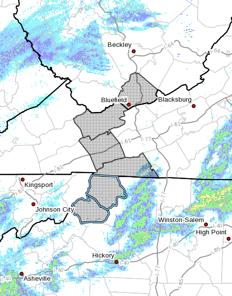
Ashe-Watauga-Tazewell-Smyth-Grayson-Mercer-
Including the cities of West Jefferson, Boone, Tazewell, Marion,
Independence, Whitetop, Troutdale, Volney, and Bluefield
254 AM EST Tue Jan 16 2024
…WINTER STORM WARNING REMAINS IN EFFECT UNTIL 7 AM EST THIS
MORNING…
…WIND CHILL ADVISORY IN EFFECT FROM 2 PM THIS AFTERNOON TO NOON
EST WEDNESDAY…
- WHAT…For the Winter Storm Warning, snow. Additional snow
accumulations of up to one inch. For the Wind Chill Advisory,
very cold wind chills expected. Wind chills as low as 5 to 20
below zero. - WHERE…Portions of northwest North Carolina, southwest
Virginia and southeast West Virginia. - WHEN…For the Winter Storm Warning, until 7 AM EST this
morning. For the Wind Chill Advisory, from 2 PM this afternoon
to noon EST Wednesday. - IMPACTS…Plan on slippery road conditions. The hazardous
conditions could impact the morning or evening commute. The
cold wind chills could cause frostbite on exposed skin in as
little as 30 minutes.
PRECAUTIONARY/PREPAREDNESS ACTIONS…
If you must travel, keep an extra flashlight, food, and water in
your vehicle in case of an emergency.
Use caution while traveling outside. Wear appropriate clothing, a
hat, and gloves.
The public is encouraged to report snowfall amounts…ice
accumulation or wind damage to the National Weather Service via
email at rnk.skywarn@noaa.gov…through Facebook or Twitter…or
by calling 1…8 6 6…2 1 5…4 3 2 4. Pictures are greatly
appreciated.
The latest road conditions for the state you are calling from can
be obtained by calling 5 1 1.


