Last Updated on February 17, 2023 9:22 am
Information provided by the North Carolina Forest Service.
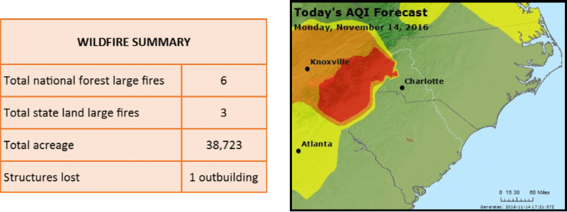
CURRENT SITUATION
Fire crews are making progress on containing fires around the region. Acreage burned continues to increase, but containment is also increasing. The weather system that moved through the region yesterday brought higher relative humidity but no significant rainfall to the fire areas. Cloud cover is expected to remain today, and any fire activity and potential will be significantly muted. These favorable weather conditions are allowing firefighters to make progress on containment. However, a high-pressure system is expected to return to the area tomorrow, with no significant chance of rain forecasted in the next 10 days.
Fire crews are making progress on containing fires around the region. Acreage burned continues to increase, but containment is also increasing. The weather system that moved through the region yesterday brought higher relative humidity but no significant rainfall to the fire areas. Cloud cover is expected to remain today, and any fire activity and potential will be significantly muted. These favorable weather conditions are allowing firefighters to make progress on containment. However, a high-pressure system is expected to return to the area tomorrow, with no significant chance of rain forecasted in the next 10 days.
AIR QUALITY INFORMATION
A code red air quality alert is in effect today for Asheville Valleys (under 4,000 feet in elevation). A code red alert for AQI (Air Quality Index) means everyone may begin to experience health effects; members of sensitive groups may experience more serious health effects. Limit your time outdoors today. Keep windows and doors closed in your home and run your HVAC.
BURNING RESTRICTIONS
A total fire ban is in effect for all lands in the Nantahala and Pisgah National Forests; however, commercially available heating equipment, portable lanterns, or stoves that use gas or pressurized liquid fuel are allowed. More information is at www.fs.usda.gov/detail/nfsnc/alerts-notices/?cid=fseprd524246.
A North Carolina Forest Service ban is in effect on all open burning in all 25 Western NC counties. More information is at ncforestservice.gov/news_pubs/newsdesk_2016.htm# 1107161.
TODAYS UPDATES ON MAJOR AREA FIRES
MAPLE SPRINGS AND OLD ROUGHY FIRES (USFS-LAKE SANTEELAH AREA, GRAHAM COUNTY)
Crews are making progress on containment of both fires. The most intense heat on the Maple Springs fire remains on the south and west corner of the fire in the Joyce Kilmer Slickrock Wilderness. If weather and smoke conditions allow, fire managers will use helicopters and water-scooping aircraft to drop water on that section of the fire today.
Maple Springs: Acreage: 7,177 – Containment: 15% – Personnel: 410 – Start Date: November 4
Old Roughy: Acreage: 657 – Containment: 60% – Start Date: November 8
Tellico Fire (USFS-NANTAHALA GORGE AREA, Swain and Macon Counties)
The southwest side-where the fire is backing downslope to Queens Creek near the community of Fairview-is the last remaining area of active fire on the Tellico Fire. On the west side, crews will monitor and mop up the fire along Highway 19/74 but limit their exposure as falling rocks and trees present a significant hazard.
Acreage: 13,676 – Containment: 39% – Personnel: 464 – Start Date: November 3
Boteler Fire (USFS-CHUNKY GAL AREA, Clay County)
Today, crews continue to construct a contingency line on the northern end of Buck Creek Road. They will also conduct burnout operations to strengthen firelines in the area north of Jackie Cove Road.
Acreage: 8,695 – Containment: 37% – Personnel: 284 – Start Date: October 25
PARTY ROCK FIRE (NCFS-LAKE LURE AREA, RUTHERFORD, BUNCOMBE, AND HENDERSON COUNTIES)
The fire continues to slowly burn down to the woods line within the Village of Chimney Rock Village's homes and businesses located just below Round Top Mountain. Structure protection firefighters are in place in multiple communities. Smoke from the fire is impacting the Asheville area. A stretch of Highway 74-A leading into Chimney Rock Village from the north and south remains closed.
Acreage: 3,457 – Containment: 15% – Personnel: 334 – Start Date: November 5
CHESTNUT KNOB FIRE (NCFS-SOUTH MOUNTAINS STATE PARK, BURKE COUNTY)
An Incident Management Team from the Florida Forest Service assumed command of the fire today. Several state parks in western North Carolina have been closed to allow the state to deploy additional resources to assist in fighting fires. In addition to South Mountains and Chimney Rock parks, New River, Elk Knob, Mount Mitchell, Lake James and Gorges state parks and Mount Jefferson State Natural Area will be closed until the fire is contained and staff can return to their assigned parks.
Acreage: 3,100 – Containment: 20% – Personnel: 118 – Start Date: November 6
ROCK MOUNTAIN FIRE (NORTHWEST OF CLAYTON, GA)
4,100 acre fire is close to the NC State Line, more info at: http://inciweb.nwcg.gov/incident/5100/
EVACUATIONS AND CLOSURES
Please visit Inciweb websites for the most up to date information:
HENDERSON COUNTY Mandatory Evacuations: communities located along Highway 64/74-A from Henderson County Line to Highway 9, Highway 9 to Shumont Road and all Henderson County homes located on Shumont Road.
Evacuation Shelter: Bat Cave Baptist Church located at 5095 Chimney Rock Road, Hendersonville, NC
SWAIN COUNTY Evacuations Lifted: Only residents are allowed on the following roads: Big Dog, Gassaway, Licklog, Long Branch, Luther Bingham, Mason, Morgan, Northern Partridge, Silver Mine, East Silver Ridge, Wesser Creek, Wilkes.
MACON COUNTY Evacuations Lifted: Only residents are allowed on Deweese and Partridge Creek Roads.
CLAY COUNTY Evacuations Lifted.
Nantahala National Forest CLOSURES
Major closures on the Nantahala include:
- Joyce Kilmer Slickrock Wilderness
- Wesser Creek Trail
- Chunky Gal Trail from Glade Gap to Tusquitee Gap
- Whitewater Falls Trail and portions of Foothills Trail
- Benton MacKaye Trail east of Beech Gap
- Appalachian Trail from the Nantahala River at Wesser south to Rock Gap Trailhead on Forest Road 67