Last Updated on February 13, 2022 8:42 am
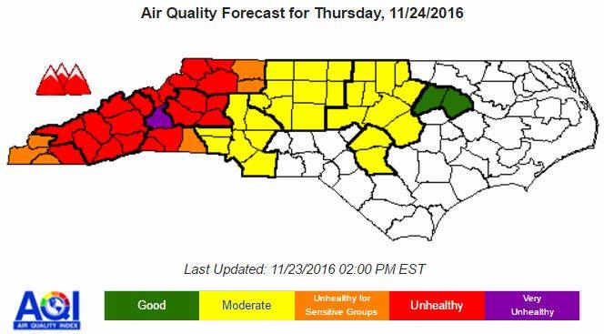
Continued smoke from the fire in Watauga County will make for an “Unhealthy” status from the NC Air Quality Forecast center for Thanksgiving Day. AppHealthCare (Appalachian District Health Department) and Appalachian Regional Healthcare System have also issued a Public Health Advisory related to the smoke.
In a late Wednesday afternoon statement NCAQF says:
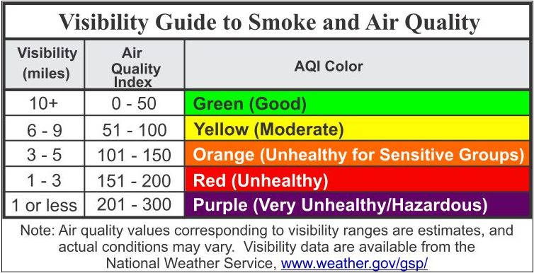
General Forecast Discussion: Tonight, the boundary layer will rapidly crash — while winds decouple — after sunset as the pressure gradient remains weak over the state. Smoke will likely begin to increase in concentration and coverage across much of western NC in the vicinity of the ongoing fires, similar to last night. With the location of new and growing fires in Watauga County (and potentially Cherokee County), along with the continuing fires in McDowell County and one each in extreme northern GA and SC, it is anticipated that smoke coverage will be widespread tonight from a line roughly extending from Rutherford County up through Alleghany County and west. It is possible — like last night — that some locations could see several hours of particle pollution concentrations over 100 micrograms. With winds light overnight, dewpoints gradually increasing into the upper 30s to lower 40s, minimal cloud coverage and light winds along with abundant smoke, it is possible that super fog could form in some valley and wind-sheltered locations by sunrise tomorrow. Visibilities could be severely limited before this fog would begin to dissipate after 9am.
Tomorrow, the synoptic pattern will feature a very weak surface pressure gradient across NC as the southeastern US remains positioned between a weak surface low dissipating over the Great Lakes and weak surface high pressure centered near Bermuda. Aloft, an upper level ridge will continue to be pushed offshore by a series of upper level disturbances lifting into New England. The results will be increasing southwesterly winds from H85 upwards, with light and variable winds at the bottom and middle of the mixed layer. What this will likely result in is a slow increase in winds through the day — with direction becoming southwesterly — as the boundary layer rises through lunchtime, before stronger winds near H85 begin to mix down to the surface later in the afternoon. This will likely result in smoke gradually pushing eastward during the day as these winds increase. It is because of this large spatial coverage of smoke that the extent of Code Red forecasts are so great tomorrow.
Outlook: On Friday, winds are expected to switch to primarily out of the west during the afternoon. The leading edge of a cold front will cross the region, but the primary wind shift and air mass change will likely lag behind the initial front. This may result in smoke moving towards the Triad, Charlotte and possibly even Triangle regions. On Saturday, the main event frontal passage should occur, resulting in a fresh, dry and cold air mass working into the region on increasing northwesterly winds. This should temporarily clear most of the state of smoke, except for locations immediately downwind of ongoing fires.