


Last Updated on August 15, 2021 4:40 pm
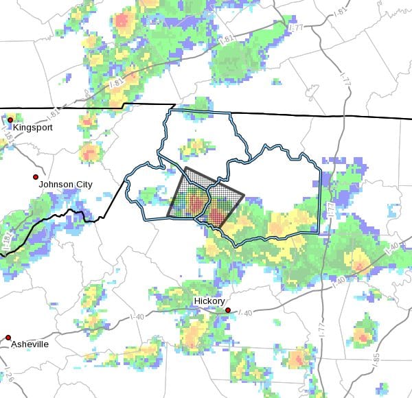
NCZ001-018-019-152100-
Ashe NC-Wilkes NC-Watauga NC-
437 PM EDT Sun Aug 15 2021
…A strong thunderstorm will impact portions of
southwestern Wilkes, southeastern Watauga and south central Ashe
Counties through 500 PM EDT…
At 437 PM EDT, Doppler radar was tracking a strong thunderstorm near
Deep Gap, moving northeast at 5 mph.
HAZARD…Winds in excess of 30 mph.
SOURCE…Radar indicated.
IMPACT…Gusty winds could knock down tree limbs and blow around
unsecured objects.
Locations impacted include…
Boone…
Blowing Rock…
Deep Gap…
Todd…
Darby…
Rutherwood…
and Cascade Falls.
PRECAUTIONARY/PREPAREDNESS ACTIONS…
If outdoors, consider seeking shelter inside a building.
Locally heavy rain will quickly reduce visibility and result in
ponding of water on roadways, standing water in low lying areas, and
minor flooding of creeks, streams, and areas of poor drainage.
Drivers are urged to slow down and use extra caution to avoid
hydroplaning.
Frequent cloud to ground lightning is occurring with this storm.
Lightning can strike 10 miles away from a thunderstorm. Seek a safe
shelter inside a building or vehicle.
This storm may intensify, so be certain to monitor local radio
stations and available television stations for additional information
and possible warnings from the National Weather Service.


