


Last Updated on July 8, 2022 6:59 pm
NCZ001-002-018-VAZ009-012-015-016-082345-
Ashe NC-Watauga NC-Alleghany NC-Grayson VA-Wythe VA-Smyth VA-
Carroll VA-
656 PM EDT Fri Jul 8 2022
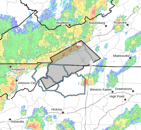
…Strong thunderstorms will impact portions of
Alleghany, central Watauga and Ashe Counties in northwestern North
Carolina, southeastern Smyth, southeastern Wythe, Carroll and Grayson
Counties in southwestern Virginia and the City of Galax through 745
PM EDT…
At 655 PM EDT, Doppler radar was tracking strong thunderstorms along
a line extending from near Fort Chiswell to near Mountain City.
Movement was southeast at 25 mph.
HAZARD…Winds in excess of 40 mph.
SOURCE…Radar indicated.
IMPACT…Gusty winds could knock down tree limbs and blow around
unsecured objects.
Locations impacted include…
Boone…
Wytheville…
Galax…
Hillsville…
Sparta…
Jefferson…
and West Jefferson.
PRECAUTIONARY/PREPAREDNESS ACTIONS…
If outdoors, consider seeking shelter inside a building.
Locally heavy rain will quickly reduce visibility and result in
ponding of water on roadways, standing water in low lying areas, and
minor flooding of creeks, streams, and areas of poor drainage.
Drivers are urged to slow down and use extra caution to avoid
hydroplaning.


