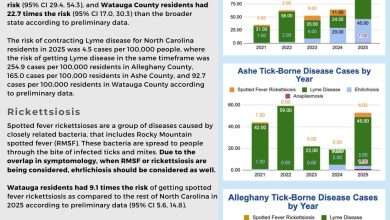
Last Updated on February 12, 2022 4:15 pm
As of Sunday morning Hurricane Matthew has been downgraded to a Post-Tropical Cyclone, but continues to have a major impact on the eastern and coastal sections of North Carolina.
In a Sunday morning update from Governor Pat McCrory, there are currently 43 local states of emergency, 40 EOCs open, and 760,000 power outages largely in the eastern part of the state. North Carolina has already had 887 swift water rescues with 562 rescues in Cumberland County alone. There have been seven deaths reported in North Carolina due to the storm.
The Governor also said that North Carolina is still facing major destruction with a big concern becoming inland flooding and rivers cresting throughout the east on Monday and Tuesday. Double digit rainfall amounts have been recorded in some eastern and coastal sections of the state, on top of already receiving significant rainfall in recent days. The Governor mention in Saturday updates that a major concern is the agricultural and livestock loss that will result from the storm.
The mountain counties of the state were not impacted by the storm. Weekend rain for the northwestern part of the state was associated with a weather system from the north that moved into the area before Matthew reached North Carolina.
The Governor's press conference from Sunday morning is below.
Governor's Office Press Release
Today, Governor McCrory is requesting an expedited major disaster declaration that will provide additional and immediate federal assistance to the state. If approved, this will provide grants to assist people without proper insurance and help state and local government officials repair bridges and roads and clean up storm debris. The governor thanked federal partners for their assistance and communications throughout Hurricane Matthew.
To date, there have been at least seven storm-related fatalities in North Carolina related to vehicles attempting to pass flooded roads. Yesterday, one fatality was reported in Sampson County caused by a vehicle that hydroplaned and two in Bladen County due to a submerged vehicle. As of this morning, one fatality in each Pitt and Sampson counties and two more in Johnston County were reported.
Additionally, one fatality was reported at a shelter in Wayne County due to a health-related issue.
The storm dumped heavy rains across the state on Saturday, with totals exceeding 6 to 8 inches across most of central and eastern North Carolina. By Saturday evening, rainfall totals topped 16 inches in Bladen County, 15 inches in Goldsboro, 12 inches in Lumberton and Smithfield, and 9 inches in Raleigh and Rocky Mount.
Torrential rains flooded roads across the state, closing and washing out roads in many locations including portions of major highways I-95, I-40 and US-70. State officials are also expecting major impacts on Highway 12 in the Outer Banks. Travelers can obtain road conditions by calling 5-1-1, visiting ReadyNC.org or using the ReadyNC mobile app.
The rains also filled many lakes and ponds to the brim. State and local officials responded to about 11 reports Saturday of dams overtopping. The National Weather Service is forecasting major river flooding across eastern North Carolina through early to mid-week, with potential record levels along the Neuse River.
Major flooding is expected along the:
- Neuse River in Clayton, Smithfield, Goldsboro and Kinston;
- Cape Fear River at Fayetteville;
- Little River in Cumberland County;
- Lumber River near Lumberton;
- Tar River in Rocky Mount, Tarboro and Greenville
- Cashie River near Windsor
- Rockfish Creek at Raeford
- Town Creek at Pine Tops
- Stony Creek at Rocky Mount
- Crabtree Creek in Raleigh
- Chowan River in Edenton
Flooding danger is particularly serious in the Fayetteville region, which experienced another 12 inches of rain yesterday in addition to 6 to 10 inches of rain last week. Flooding is also a concern along the Neuse River below Raleigh. Swift water rescue teams have made more than 900 rescues using 58 boat crews and 334 rescue personnel. Of these rescues, 562 were in Cumberland County alone, where the state is working with numerous Swift Water Rescue teams from other states that have been brought in to help.
Governor McCrory announced that 300 North Carolina National Guard troops and 105 high water vehicles have been deployed to assist with rescues. More National Guard resources are expected to deploy today.
The State Highway Patrol has sent additional troopers to impacted areas to address road safety issues. The N.C. Department of Transportation is also surging resources into impacted areas to open roads that have been closed. The Wildlife Resources Commission has been working with the Department of Public Safety and State Highway Patrol to assist with rescues of people and animals. The U.S. Coast Guard is also assisting with ongoing rescues throughout the state.
The governor said that the State Highway Patrol is working to address 9-1-1 system outages in Currituck, Bladen, Moore, Columbus and Robeson counties. The state is also monitoring water system issues in Fayetteville, Sanford, Chocowinity, Beaufort, Gates and Johnston counties.
The rainfall and high winds led to many power outages across the state. As of 9:00 a.m. this morning, power outages totaled more than 800,000 statewide, which includes more than 440,000 in eastern North Carolina and 319,000 in the central part of the state. Utilities have deployed thousands of workers to respond to power outages in North and South Carolina.
More than 80 emergency shelters have opened in central and eastern North Carolina and are currently housing more than 4,400 people. For those needing information, including nearby shelter, housing, and other storm-related details, call 2-1-1.
For more information about how to get ready for a hurricane and what to do during or after a storm, go to ReadyNC.org. You can also get real-time traffic and weather updates on the ReadyNC mobile app. Follow N.C. Emergency Management on Twitter and Facebook for the latest on Hurricane Matthew.