Last Updated on April 11, 2026 9:27 pm
The National Weather Service office in Blacksburg is warning of potentially record-breaking heat for the High Country by the middle of next week, with forecasters also sounding the alarm about worsening drought and fire conditions.
In its Saturday evening Area Forecast Discussion, the NWS said a strong upper-level ridge of high pressure building over the Southeast will drive temperatures well above normal heading into the week. Forecasters said temperatures could approach or break record highs by Tuesday.
The warming trend follows a dry frontal passage Saturday afternoon that brought some clouds and breezy conditions to the region. High pressure will remain in control through the end of the week, keeping any significant rainfall chances low. Some orographic convection — thunderstorms generated by the mountains — may creep into the higher elevations after Wednesday as a front approaches, but the NWS said the probability of substantial rainfall remains low through the end of next week.
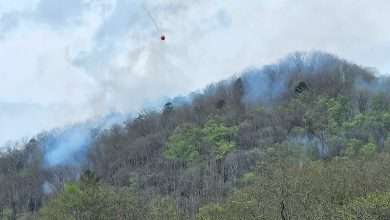
The prolonged heat and ongoing lack of rain are expected to worsen already significant drought conditions across the region and increase fire danger. Portions of the High Country are already at D2 Severe Drought, with Wilkes County recently elevated to D3 Extreme Drought.
“Expect worsening drought and fire risk,” forecasters wrote. “The prolonged heat and lack of rain will worsen ongoing drought conditions. This also creates an environment making it difficult for fire suppression; any new fires will be difficult to contain.”
The statewide burn ban remains in effect across all 100 North Carolina counties.
Forecast courtesy of the National Weather Service.