Last Updated on January 3, 2023 9:56 am
The National Weather Service Blacksburg office, which serves Watauga and Ashe counties, has announced their Top 5 Weather Events of 2022.
Two of the five were High Country related, the winter storm of January 16-17 and the recent record cold of December 23-26. The entire Top 5 list can be found below.
1. Remnants of Ian bring damaging winds resulting in one fatality
Photo: Chatham Star-Tribune

Numerous trees were blown down across the foothills and Piedmont of North
Carolina and the Virginia Piedmont as the remains of Ian moved across our
region. Tens of thousands of people were temporarily without power. In
Pittsylvania county, 42% of customers were without power at the peak of the
event. In Campbell County, One tree fell on a car while it was traveling along
the 2200 block of Bishop Creek Road, causing the car to run off the road, and
the driver was killed. Four families were displaced in Lynchburg when trees
fell on homes and an apartment. In Halifax county, four residences were
damaged from down trees, including one family that was displaced.
2. May 26-27, 2022 Tornadoes
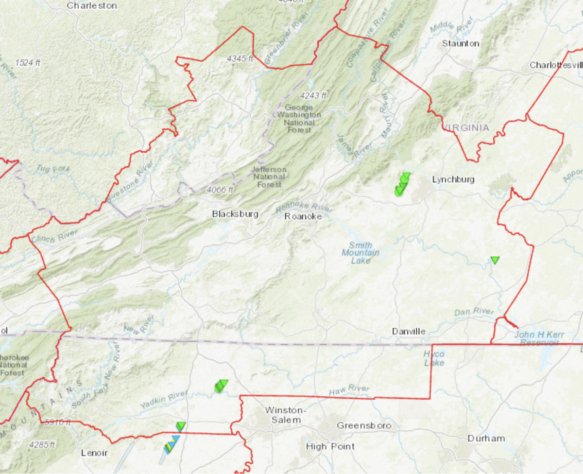
From the evening of May 26th to the morning of May 27th, four known
tornadoes touched down in the NWS Blacksburg forecast area.
The first tornado developed at 7:13 PM on May 26th in Yadkin County. This EF1
tornado had maximum winds estimated to be 95 mph with a path length of
1.5 miles. The tornado touched down in a small wooded area just west of
Howards Branch Road and proceeded north-northeast until lifting along
Redbud Lane. Almost all direct damage consisted of numerous mature trees
either snapped or uprooted, although one shed was also destroyed.
The second tornado touched down in Surry County at 11:03 PM on May 26th.
This EF-1 tornado also had maximum winds around 95 mph and touchdown 2.1
miles west northwest of Siloam. The tornado was on the ground for approximately2.8 miles with a path width of 100 yards. Numerous hardwood and softwood trees
were either snapped or uprooted along the path of the tornado. No homes were
damaged nor were there any injuries. The tornado lifted in a wooded area a couple
hundred yards from Stanford Church Road.
The third tornado of this event was the most destructive. During the morning of May
27th, a high end EF2 tornado with maximum winds of 135 mph touchdown 0.4
miles southeast of Norwood before heading north northeast toward U.S
Highway 221. The tornado crossed Bethany Church Road and Langford Lane
where two mobile homes were destroyed. The tornado then continued
northeast snapping and uprooting trees just west of the Ivy Hill Golf Course.
Additional tree damage was noted on the western slopes of Fleming
Mountain along Rocky Mountain Road. In total, 15 homes were damaged
along with 35 structures including sheds, outbuildings, and garages. Three
injuries were reported with zero fatalities. The length of the tornado track was
estimated at 6.25 miles, and the maximum width was approximately 330
yards.
The final tornado for this event in the NWS Blacksburg forecast area briefly
touched down in Charlotte County on the morning of May 27th. This EF-1
tornado with maximum wind gusts around 95 mph, briefly touched down
and primarily affected one private residence along Green View Road.
Significant roof damage along with glass doors and windows were broken on
the home. A few trees and power lines were also damaged along Green View
Road before the tornado lifted.
3. Jan 16-17 Winter Storm
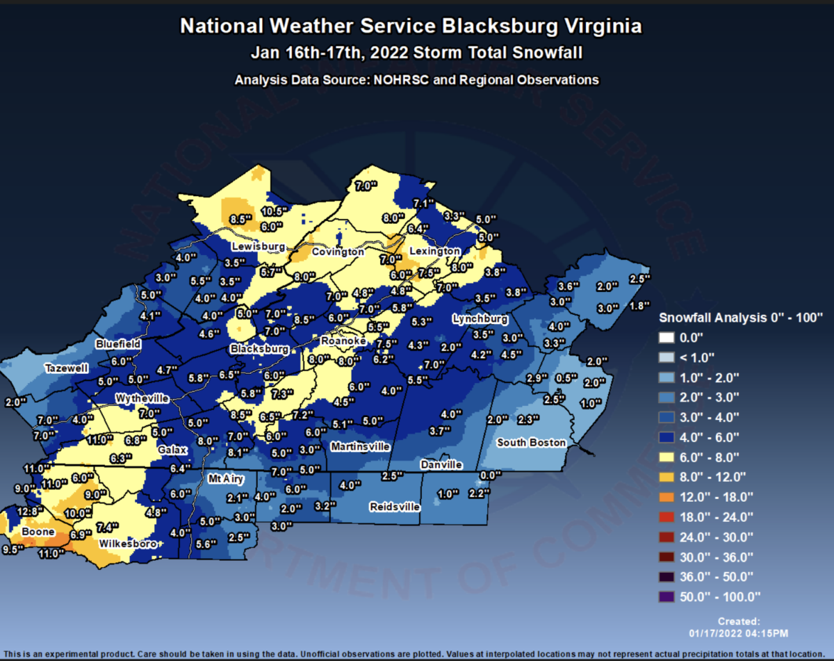
A wintry mix of snow, sleet and freezing rain resulted in several accidents and
thousands of power outages. 3-10” of snow and sleet were common from
northwest NC to the Greenbrier Valley and Alleghany Highlands. After the
precipitation ceased, powerful northwest winds brought down several trees
across northwest North Carolina and southwest Virginia. In Carroll County,
two cars were struck by falling trees on Interstate 77 near exit 14. A peak wind
gust of 68 MPH was measured at Boone, and a 75 MPH wind gust was
measured at a personal weather station in Blowing Rock,NC.
4. Record cold temperatures December 23 – December 26 2022
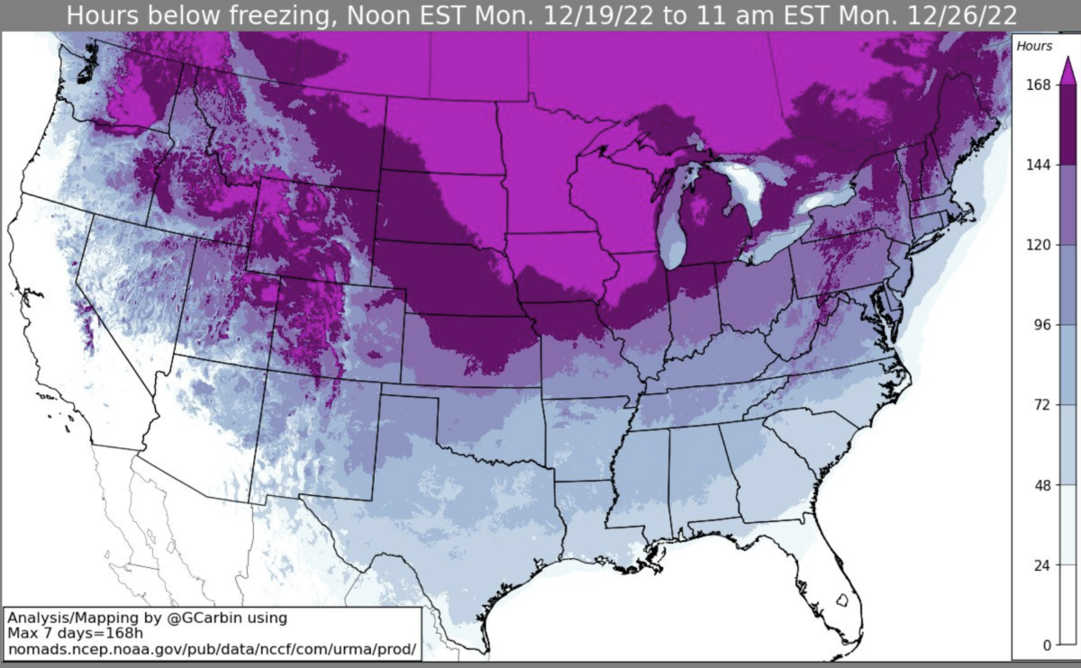
A powerful Arctic blast of bitterly cold air impacted two-thirds of the
continental U.S. over the Christmas Holiday weekend, including the entire
Blacksburg forecast area. In addition to record cold, strong winds produced
widespread wind damage knocking out power to over 50,000 AEP customers,
leaving some people without the ability to heat their homes. Dangerous wind
chills were observed with readings ranging from 15 below zero in the
piedmont, to as much as 40 below zero in the mountains.
Location Coldest Temperature Date Coldest Since
Blacksburg -4 12/24 2/21/2015 (-5)
Roanoke 3 12/14 2/20/2015 (0)
Lynchburg 4 12/24 1/7/2018 (-2)
Bluefield -9 12/23-24 2/5/1996 (-9)
Danville 6 12/25 1/3/2018 (5)
5. July 12th, 2022 Tazewell County Flash Flood
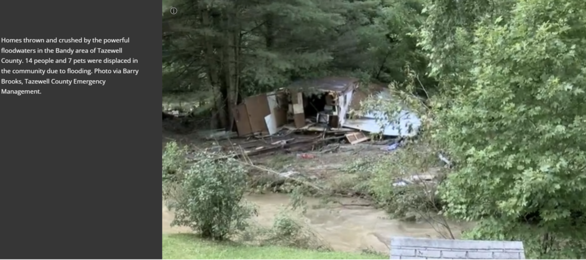
Numerous homes and public buildings flooded by anywhere from 6 inches to
2 feet of water from Indian Creek as it flooded out of its banks within the
community of Bandy. At least 14 residents in the area were evacuated to
shelters, however no injuries were reported.
More details about this event can be found here:
https://storymaps.arcgis.com/stories/fcb54c51bde7480da7f065844626c62b