


Last Updated on September 5, 2022 4:34 am
NCZ001>004-018>020-VAZ007-009>020-022>024-032>035-043-WVZ042>044-507-
508-051615-
/O.NEW.KRNK.FA.A.0009.220905T0814Z-220906T0300Z/
/00000.0.ER.000000T0000Z.000000T0000Z.000000T0000Z.OO/
Ashe-Alleghany NC-Surry-Stokes-Watauga-Wilkes-Yadkin-Tazewell-Smyth-
Bland-Giles-Wythe-Pulaski-Montgomery-Grayson-Carroll-Floyd-Craig-
Alleghany VA-Bath-Roanoke-Botetourt-Rockbridge-Patrick-Franklin-
Bedford-Amherst-Henry-Mercer-Summers-Monroe-Eastern Greenbrier-
Western Greenbrier-
Including the cities of Bluefield, Bedford, Volney, Alderson, Hix,
Radford, Salem, Stuart, Flat Top, New Castle, Quinwood, Tazewell,
Clifton Forge, Martinsville, Roanoke, Hot Springs, Amherst,
Fincastle, Rocky Mount, Lewisburg, Wilkesboro, Pearisburg, Sparta,
Dobson, Troutdale, Rainelle, Buena Vista, Pulaski, West Jefferson,
Duo, Yadkinville, Covington, Galax, Whitetop, Blacksburg, Floyd,
Boone, Independence, Union, White Sulphur Springs, Marion, Danbury,
Bland, Wytheville, Hinton, and Lexington
414 AM EDT Mon Sep 5 2022
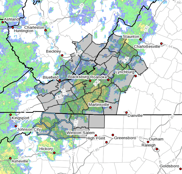
…FLOOD WATCH IN EFFECT THROUGH THIS EVENING…
- WHAT…Flash flooding caused by excessive rainfall is possible.
- WHERE…Portions of North Carolina, Virginia and southeast West
Virginia, including the following areas, in North Carolina,
Alleghany NC, Ashe, Stokes, Surry, Watauga, Wilkes and Yadkin. In
Virginia, Alleghany VA, Amherst, Bath, Bedford, Bland, Botetourt,
Carroll, Craig, Floyd, Franklin, Giles, Grayson, Henry,
Montgomery, Patrick, Pulaski, Roanoke, Rockbridge, Smyth, Tazewell
and Wythe. In southeast West Virginia, Eastern Greenbrier, Mercer,
Monroe, Summers and Western Greenbrier. - WHEN…Through this evening.
- IMPACTS…Excessive runoff may result in flooding of rivers,
creeks, streams, and other low-lying and flood-prone locations. - ADDITIONAL DETAILS…
- Periods of rain can be expected throughout the day…heavy at
times. If thunderstorms develop, the rain may become
excessive resulting in rapid runoff and sudden stream rises.
Average rainfall amounts of 1 to 3 inches can be expected
along and west of the Blue Ridge. Locally higher amounts of 3
to 5 inches are possible where showers and thunderstorms
persist. - http://www.weather.gov/safety/flood
PRECAUTIONARY/PREPAREDNESS ACTIONS…
You should monitor later forecasts and be alert for possible Flood
Warnings. Those living in areas prone to flooding should be prepared
to take action should flooding develop.


