


Last Updated on December 26, 2023 5:19 pm
Event extended (time)
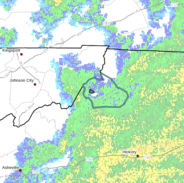
…Minor Flooding Continued Along the Watauga River at Sugar Grove…
NCC189-270100-
/O.EXT.KRNK.FA.W.0022.000000T0000Z-231227T0100Z/
/00000.0.ER.000000T0000Z.000000T0000Z.000000T0000Z.OO/
Watauga NC-
503 PM EST Tue Dec 26 2023
…FLOOD WARNING NOW IN EFFECT UNTIL 8 PM EST THIS EVENING…
* WHAT…Flooding caused by excessive rainfall continues.
* WHERE…A portion of northwest North Carolina, including the
following county, Watauga.
* WHEN…Until 800 PM EST.
* IMPACTS…Flooding of rivers, creeks, streams, and other low-lying
and flood-prone locations is imminent or occurring. It will take
several hours for all the water from these storms to work through
local drainage.
* ADDITIONAL DETAILS…
– At 451 PM EST, Doppler radar and automated rain gauges
indicated heavy rain. Flooding is ongoing or expected to
begin shortly. Between 1.5 and 2.5 inches of rain have
fallen. At 4:30 PM Watauga River at Sugar Grove was 5.7 feet
and falling. Flood Stage is 6 feet. The river is expected to
begin rising again around 7 PM and will crest near 8.0 feet.
At this level several low water bridges begin to flood
including Dewitt Barnett Road, Hubert Thomas Road, and
Watauga River Road.
– Additional rainfall amounts up to 1 inch are possible in the
warned area.
– Some locations that will experience flooding include…
Rominger.
– http://www.weather.gov/safety/flood
PRECAUTIONARY/PREPAREDNESS ACTIONS…
Turn around, don't drown when encountering flooded roads. Most flood
deaths occur in vehicles.
Be especially cautious at night when it is harder to recognize the
dangers of flooding.
In hilly terrain there are hundreds of low water crossings which are
potentially dangerous in heavy rain. Do not attempt to cross flooded
roads. Find an alternate route.
…Flood Warning Issued for the Watauga River near Sugar Grove and Surrounding Tributaries… Overnight and early morning rainfall of 2-3 inches was common in the Watauga River basin. This has resulted in significant rises in river levels within the Watauga River basin, including the Watauga River at Sugar Grove. Minor flooding is occurring or is expected in this region through the afternoon.
NCC189-262300-
/O.NEW.KRNK.FA.W.0022.231226T1700Z-231226T2300Z/
/00000.0.ER.000000T0000Z.000000T0000Z.000000T0000Z.OO/
Watauga NC-
1200 PM EST Tue Dec 26 2023
…FLOOD WARNING IN EFFECT UNTIL 6 PM EST THIS EVENING…
- WHAT…Flooding caused by excessive rainfall.
- WHERE…A portion of northwest North Carolina, including the
following county, Watauga. - WHEN…Until 600 PM EST Tuesday.
- IMPACTS…Flooding of rivers, creeks, streams, and other low-lying
as well as flood-prone locations is imminent or is already
occurring. - ADDITIONAL DETAILS…
- At 1152 AM EST, During the past 24 hours, rainfall of 2 to 3
inches, with local rainfall amounts near 4 inches, has been
common throughout the Watauga River basin. This has resulted
in flooding along the Watauga River near Sugar Grove, as well
as its tributaries. At 1145 AM EST, the Watauga River had
risen to 6.6 ft. Flood stage is 6.0 ft. Indications are that
the river will continue to rise to near 8 ft. this afternoon,
which is minor flood stage. The river will likely remain in
flood through the evening hours. Exactly when the river will
drop below flood stage depends on the amount of additional
rainfall expected during the next 12-18 hours. - Some locations that will experience flooding include…
Rominger and Sugar Grove, as well as areas along U.S. Highway
321 near Sugar Grove. - For additional information please go to
http://www.weather.gov/safety/flood
PRECAUTIONARY/PREPAREDNESS ACTIONS…
Precautionary/Preparedness Action: Turn around, don't drown when
encountering flooded roads. Most flood deaths occur in vehicles.


