Last Updated on June 20, 2023 11:57 am
NCC011-023-111-121-161-199-202130-
/O.NEW.KGSP.FA.Y.0054.230620T1551Z-230620T2130Z/
/00000.N.ER.000000T0000Z.000000T0000Z.000000T0000Z.OO/
Avery NC-Burke NC-McDowell NC-Mitchell NC-Rutherford NC-Yancey NC-
1151 AM EDT Tue Jun 20 2023
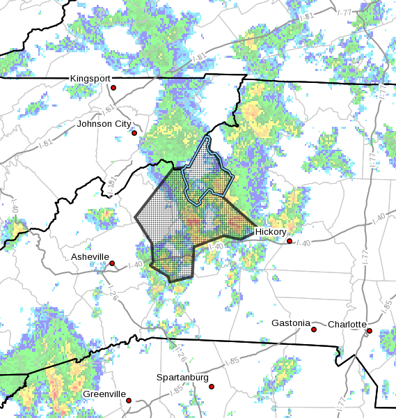
…FLOOD ADVISORY IN EFFECT UNTIL 530 PM EDT THIS AFTERNOON…
- WHAT…Flooding caused by excessive rainfall is expected.
- WHERE…A portion of western North Carolina, including the
following counties, Avery, Burke, McDowell, Mitchell, Rutherford
and Yancey. - WHEN…Until 530 PM EDT.
- IMPACTS…Nuisance to Minor flooding of low-lying areas adjacent
to streams and other poor-drainage areas, including farmland,
greenways, parks, boat-access areas, golf courses, low-water
crossings, and low-lying roadways. High flows over low-water
crossings and low-lying roadways are possible and water may
approach low-lying structures. - ADDITIONAL DETAILS…
- At 1138 AM EDT, Doppler radar and rain gauges have reported
2-5 inches of rainfall since midnight along the northern Blue
Ridge Escarpment, adjacent foothills, and northern NC
mountains. Areas of McDowell County from Lake Tahoma to
Pleasant Gardens to Marion to Woodlawn have received isolated
totals of 6 inches, with at least three inches occurring from
training showers and thunderstorms over the last 2-3 hours.
This has caused areas of Minor flooding impacting several
low-water crossings and secondary roads, with water
approaching properties. Additional nuisance to Minor
flooding is likely across the northern NC mountains,
including and especially the headwaters and tributaries of
several streams including the North Fork Catawba River,
Linville River, upper Catawba River, Buck Creek, Warrior
Fork, South Toe River, Cane River, and the North Toe River. - Showers and thunderstorms will continue to develop through
the afternoon hours. These showers will be very efficient at
producing heavy rainfall and soils are saturated. Therefore,
additional heavy rain will quickly create new areas of
flooding and cause previous areas of flooding to redevelop.
Caution is advised near any stream or other vulnerable area.
Seek higher ground immediately when heavy rain develops.
Flash Flood Warnings may be issued during the day and into
the nighttime hours. Please have a plan in place should
flash flooding develop and do not hesitate to act. - Some locations that may experience flooding include…
Morganton, Marion, Spruce Pine, Burnsville, Newland, Drexel,
Old Fort, Banner Elk, Elk Park, Bakersville, Beech Mountain
In Avery County, Crossnore, Sugar Mountain, Seven Devils,
Linville Falls, Lake James State Park.
PRECAUTIONARY/PREPAREDNESS ACTIONS…
In hilly terrain there are hundreds of low water crossings which are
potentially dangerous in heavy rain. Do not attempt to cross flooded
roads. Find an alternate route.
Flooding is occurring or is imminent. It is important to know where
you are relative to streams, rivers, or creeks which can become
killers in heavy rains. Campers and hikers should avoid streams or
creeks.