Last Updated on July 19, 2024 7:29 pm
NCC011-023-027-111-121-200230-
/O.NEW.KGSP.FA.Y.0096.240719T2324Z-240720T0230Z/
/00000.N.ER.000000T0000Z.000000T0000Z.000000T0000Z.OO/
Avery NC-Burke NC-Caldwell NC-McDowell NC-Mitchell NC-
724 PM EDT Fri Jul 19 2024
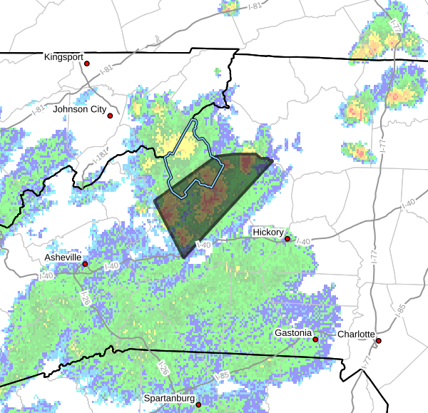
…FLOOD ADVISORY IN EFFECT UNTIL 1030 PM EDT THIS EVENING…
- WHAT…Urban and small stream flooding caused by excessive
rainfall is expected. - WHERE…A portion of western North Carolina, including the
following counties, Avery, Burke, Caldwell, McDowell and Mitchell. - WHEN…Until 1030 PM EDT.
- IMPACTS…Minor flooding in low-lying and poor drainage areas.
Water over roadways. - ADDITIONAL DETAILS…
- At 724 PM EDT, Doppler radar indicated heavy rain due to
thunderstorms. This will cause urban and small stream
flooding. Between 2 and 3 inches of rain have fallen. - Additional rainfall amounts up to 1 inch are expected over
the area. This additional rain will result in minor flooding. - Some locations that will experience flooding include…
Marion, Spruce Pine, Blowing Rock In Caldwell County,
Crossnore, Table Rock, B.R. Parkway-Linville Falls To
Grandfather, Linville Falls, B.R. Parkway-Little Switzerland
To Linville, Lake James State Park, Lake James, Grandfather
Mountain State Park, B.R. Parkway-Craggy To Little
Switzerland, Jonas Ridge, Edgemont, Ashford, Pineola,
Linville, Collettsville, Globe and North Cove. - http://www.weather.gov/safety/flood
PRECAUTIONARY/PREPAREDNESS ACTIONS…
When it is safe to do so, please report flooding or landslides
threatening roads or property to the National Weather Service
Greenville-Spartanburg by calling toll free, 1, 800, 2 6 7, 8 1 0 1,
by posting on our Facebook page, or via Twitter using hashtag
NWSGSP. Your message should describe the specific location where
impacts occurred and the depth of flooding observed.
Turn around, don't drown when encountering flooded roads. Most flood
deaths occur in vehicles.


