Last Updated on September 9, 2023 9:40 am
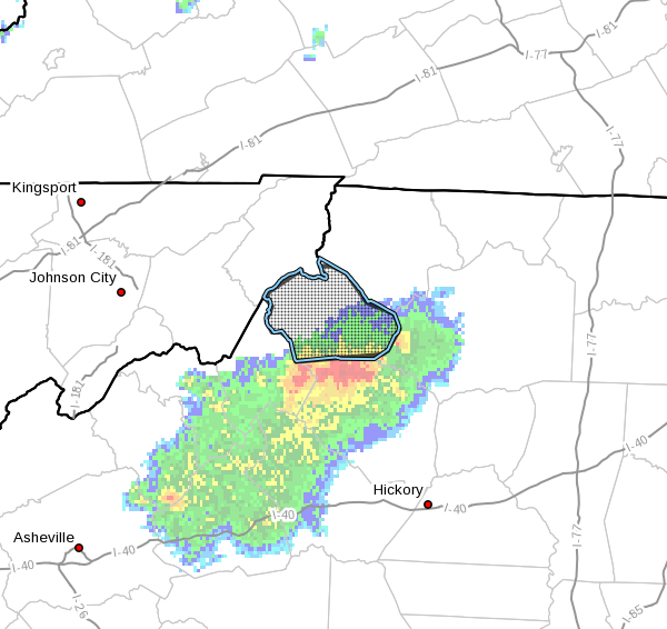
…Flood Advisory in Effect for Watauga County Until 1130 AM EDT This Morning…
NCC189-091530-
/O.NEW.KRNK.FA.Y.0105.230909T1329Z-230909T1530Z/
/00000.N.ER.000000T0000Z.000000T0000Z.000000T0000Z.OO/
Watauga NC-
929 AM EDT Sat Sep 9 2023
…FLOOD ADVISORY IN EFFECT UNTIL 1130 AM EDT THIS MORNING…
- WHAT…Flooding as a result of thunderstorms with heavy rainfall
moving into the county from the south - WHERE…Watauga County.
- WHEN…Until 1130 AM EDT.
- IMPACTS…Minor flooding in low-lying and poor drainage areas.
Overflowing poor drainage areas. - ADDITIONAL DETAILS…
- At 926 AM EDT, Doppler radar indicated heavy rain due to
thunderstorms moving north from Caldwell and Avery counties.
From 1 to 2 inches of rain is possible from this activity
during the next hour. This amount of rainfall on saturated
ground from previous rainfall could result in minor flooding.
Flooding will be possible in poor drainage, low-lying, and
normally flood prone areas. - This includes the following streams and drainages…
Dutch Creek, George Gap Branch, Fall Creek, Beech Creek,
Brushy Fork, Craborchard Creek, Flat Branch, Elk Creek,
Beaverdam Creek, Cove Creek and Dugger Creek.
- Some locations that will experience flooding include…
Boone… Blowing Rock…
Beech Mountain… Foscoe…
Sugar Grove… Todd…
Deep Gap…
- For additional information on rainfall, creeks, streams, and
rivers within our forecast area, please visit our web site
located at: http://www.weather.gov/safety/flood
PRECAUTIONARY/PREPAREDNESS ACTIONS…
Precautionary/Preparedness Statements: In hilly terrain there are
hundreds of low water crossings which are potentially dangerous in
heavy rain. Do not attempt to cross flooded roads. Find an alternate
route.
When it is safe to do so, please send your reports of flooding,
including mudslides or flooded roads, to the National Weather
Service by calling toll free at 1…8 6 6…2 1 5…4 3 2 4. Reports
and pictures can also be shared on the National Weather Service
Blacksburg Facebook page and on Twitter.


