Last Updated on January 9, 2024 12:04 pm
NCC011-027-100045-
/O.NEW.KGSP.FF.W.0011.240109T1659Z-240110T0045Z/
/00000.0.ER.000000T0000Z.000000T0000Z.000000T0000Z.OO/
BULLETIN – EAS ACTIVATION REQUESTED
Flash Flood Warning
National Weather Service Greenville-Spartanburg SC
1159 AM EST Tue Jan 9 2024
The National Weather Service in Greenville-Spartanburg has issued a
- Flash Flood Warning for…
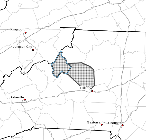
Avery County in western North Carolina…
Caldwell County in western North Carolina… - Until 745 PM EST Tuesday.
- At 1159 AM EST, Doppler radar indicated thunderstorms producing
heavy rain across the warned area. Between 2 and 4 inches of rain
have fallen since early Tuesday morning. Additional rainfall
amounts of 1 to 3 inches are possible in the warned area. Onset
flash flooding is developing and significant flash flooding is
expected to begin shortly. This will be a prolonged event with
new areas of flash flooding developing throughout the afternoon
hours. Significant rises and adjacent flooding of Wilson Creek,
Linville River, North Toe River, Johns River, Mulberry Creek,
Buffalo Creek, Lower Creek, and the headwaters of the Yadkin
River. Expect some flooding to be significant with damaging
impacts to roadways and structures. Please seek higher ground
immediately and stay away from flooded roads. Campground
residents and visitors are encouraged to seek higher ground until
streams crest and recede on Wednesday. Extreme caution while
traveling is advised.
HAZARD…Life threatening flash flooding. Thunderstorms
producing flash flooding.
SOURCE…Radar.
IMPACT…Life threatening flash flooding of creeks and streams,
low-lying areas, urban areas, highways, streets and
underpasses. Significant inundation of low-water
crossings, outbuildings, and several secondary roads
is likely. Flooding of crawlspaces and basements is
possible. Culvert and road washouts are possible.
Campgrounds may experience significant flooding,
capable of sweeping away campers and RVs.
- Some locations that may experience significant flash flooding
include…
Lenoir, Newland, Sawmills, Granite Falls, Gamewell, Bethlehem,
Hudson, Cajah's Mountain, Blowing Rock In Caldwell County, Banner
Elk, Rhodhiss, Elk Park, Cedar Rock, Crossnore, Sugar Mountain,
Seven Devils,
PRECAUTIONARY/PREPAREDNESS ACTIONS…
Heavy rain is increasing the risk of landslides, especially in areas
where slides have occurred in the past. Be especially alert if you
are near a stream, especially at the base of a mountain or in a
cove. Watch for loose-moving soil and rocks or a sudden increase in
streamflow. Leave the area quickly if this is observed. When driving
along roads where the terrain is steep or rocky, watch and listen
for falling rocks, mud, trees and other debris.
In hilly terrain there are hundreds of low water crossings which are
potentially dangerous in heavy rain. Do not attempt to cross flooded
roads. Find an alternate route.
Flooding is occurring or is imminent. It is important to know where
you are relative to streams, rivers, or creeks which can become
killers in heavy rains. Campers and hikers should avoid streams or
creeks.