Alerts
-
Nov- 2025 -15 November
Wind Advisory Issued for Watauga, Ashe Counties Through Sunday Noon
Wind Advisory Issued for Watauga, Ashe Counties Through Sunday Noon | WataugaOnline.com Wind Advisory Issued for Watauga, Ashe Counties Through…
Read More » -
9 November
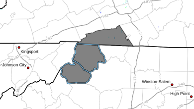
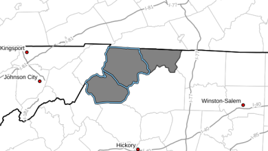
Winter Weather Advisory including Watauga & Ashe – November 9-11, 2025
NCZ001-018-VAZ015-091545-/O.NEW.KRNK.WW.Y.0015.251110T0000Z-251111T1200Z/Ashe-Watauga-Grayson-Including the cities of Independence, Whitetop, Boone, Volney,West Jefferson, and Troutdale242 AM EST Sun Nov 9 2025 …WINTER WEATHER ADVISORY…
Read More » -
9 November
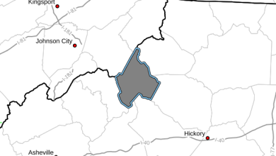
Winter Weather Advisory for Avery County – November 9-11, 2025
NCZ033-091430-/O.NEW.KGSP.WW.Y.0009.251110T0000Z-251111T1200Z/Avery-Including the cities of Ingalls, Newland, and Banner Elk120 AM EST Sun Nov 9 2025 …WINTER WEATHER ADVISORY IN EFFECT…
Read More » -
4 November
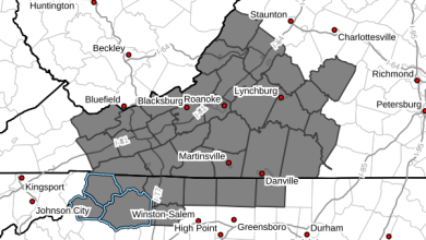
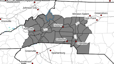
Special Weather Statement for Watauga & Ashe – Increased Fire Danger – Wednesday November 5, 2025
NCZ001>006-018>020-VAZ007-009>020-022>024-032>035-043>047-058-059-050900-Ashe-Alleghany NC-Surry-Stokes-Rockingham-Caswell-Watauga-Wilkes-Yadkin-Tazewell-Smyth-Bland-Giles-Wythe-Pulaski-Montgomery-Grayson-Carroll-Floyd-Craig-Alleghany VA-Bath-Roanoke-Botetourt-Rockbridge-Patrick-Franklin-Bedford-Amherst-Henry-Pittsylvania-Campbell-Appomattox-Buckingham-Halifax-Charlotte-Including the cities of West Jefferson, Sparta, Dobson, Danbury,Eden, Yanceyville, Boone, Wilkesboro, Yadkinville, Tazewell,Marion, Bland, Pearisburg, Wytheville, Radford,…
Read More » -
4 November
Special Weather Statement for Avery County – Increased Fire Danger – Wednesday November 5, 2025
NCZ033-035>037-048>050-053-056-057-064-065-068>072-082-501>510-050615-Avery-Alexander-Iredell-Davie-Madison-Yancey-Mitchell-Buncombe-Catawba-Rowan-Transylvania-Henderson-Cleveland-Lincoln-Gaston-Mecklenburg-Cabarrus-Union-Caldwell Mountains-Greater Caldwell-Burke Mountains-Greater Burke-McDowell Mountains-Eastern McDowell-Rutherford Mountains-Greater Rutherford-Polk Mountains-Eastern Polk-107 PM EST Tue Nov 4 2025 …INCREASED FIRE DANGER…
Read More » -
Oct- 2025 -30 October
Wind Advisory including Watauga & Ashe – October 30-31, 2025
NCZ001-002-018-310300-/O.NEW.KRNK.WI.Y.0014.251031T0000Z-251031T1200Z/Ashe-Alleghany NC-Watauga-Including the cities of Sparta, West Jefferson, and Boone132 PM EDT Thu Oct 30 2025 …WIND ADVISORY IN EFFECT…
Read More » -
30 October
NWS Hazardous Weather Outlook including Watauga, Ashe & Wilkes for Thursday October 30, 2025
Hazardous Weather OutlookNational Weather Service Blacksburg VA211 AM EDT Thu Oct 30 2025 NCZ001-002-018-VAZ007-009>020-022>024-WVZ042>044-507-508-310615-Ashe-Alleghany NC-Watauga-Tazewell-Smyth-Bland-Giles-Wythe-Pulaski-Montgomery-Grayson-Carroll-Floyd-Craig-Alleghany VA-Bath-Roanoke-Botetourt-Rockbridge-Mercer-Summers-Monroe-Eastern Greenbrier-Western Greenbrier-211 AM EDT…
Read More » -
29 October
NWS Hazardous Weather Outlook including Watauga, Ashe & Wilkes for Wednesday October 29, 2025
Hazardous Weather OutlookNational Weather Service Blacksburg VA206 AM EDT Wed Oct 29 2025 NCZ001>003-018-019-VAZ007-009>020-022>024-032>035-WVZ042>044-507-508-300615-Ashe-Alleghany NC-Surry-Watauga-Wilkes-Tazewell-Smyth-Bland-Giles-Wythe-Pulaski-Montgomery-Grayson-Carroll-Floyd-Craig-Alleghany VA-Bath-Roanoke-Botetourt-Rockbridge-Patrick-Franklin-Bedford-Amherst-Mercer-Summers-Monroe-Eastern Greenbrier-Western Greenbrier-206 AM EDT…
Read More » -
27 October
NWS Hazardous Weather Outlook including Watauga, Ashe & Wilkes for Monday October 27, 2025
Hazardous Weather OutlookNational Weather Service Blacksburg VA338 AM EDT Mon Oct 27 2025 NCZ001>006-018>020-VAZ007-009>020-022>024-032>035-043>045-WVZ042>044-507-508-280745-Ashe-Alleghany NC-Surry-Stokes-Rockingham-Caswell-Watauga-Wilkes-Yadkin-Tazewell-Smyth-Bland-Giles-Wythe-Pulaski-Montgomery-Grayson-Carroll-Floyd-Craig-Alleghany VA-Bath-Roanoke-Botetourt-Rockbridge-Patrick-Franklin-Bedford-Amherst-Henry-Pittsylvania-Campbell-Mercer-Summers-Monroe-Eastern Greenbrier-Western Greenbrier-338 AM EDT…
Read More » -
23 October
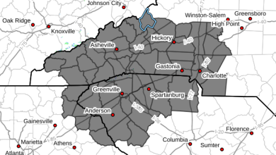
Special Weather Statement for Avery County – Increased Fire Danger – Thursday October 23, 2025
GAZ010-017-018-026-028-029-NCZ033-035>037-048>053-056>059-062>065-068>072-082-501>510-SCZ008>014-019-101>109-232300-Rabun-Habersham-Stephens-Franklin-Hart-Elbert-Avery-Alexander-Iredell-Davie-Madison-Yancey-Mitchell-Swain-Haywood-Buncombe-Catawba-Rowan-Graham-Northern Jackson-Macon-Southern Jackson-Transylvania-Henderson-Cleveland-Lincoln-Gaston-Mecklenburg-Cabarrus-Union-Caldwell Mountains-Greater Caldwell-Burke Mountains-Greater Burke-McDowell Mountains-Eastern McDowell-Rutherford Mountains-Greater Rutherford-Polk Mountains-Eastern Polk-Cherokee-York-Anderson-Abbeville-Laurens-Chester-Greenwood-Oconee Mountains-Pickens Mountains-Greenville Mountains-Greater Oconee-Greater Pickens-Central Greenville-Southern Greenville-Northern…
Read More »


