Last Updated on January 17, 2021 2:37 pm
…Accumulating Snow Tonight and Early Monday… .An upper level disturbance will provide for additional snowfall tonight and early Monday. Elevations above 3500 feet will experience the greatest accumulation.
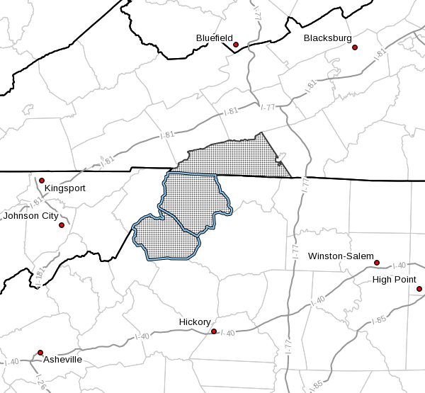
NCZ001-018-VAZ015-180345-
/O.NEW.KRNK.WW.Y.0005.210118T0300Z-210118T1700Z/
Ashe-Watauga-Grayson-
231 PM EST Sun Jan 17 2021
…WINTER WEATHER ADVISORY IN EFFECT FROM 10 PM THIS EVENING TO
NOON EST MONDAY ABOVE 3500 FEET…
- WHAT…Snow expected, with the greatest accumulation above 3500
feet. Total new snow accumulation of up to three inches. Winds
gusting as high as 40 mph. - WHERE…In Virginia, Grayson County. In North Carolina, Ashe
and Watauga Counties. - WHEN…From 10 PM this evening to noon EST Monday.
- IMPACTS…Plan on slippery road conditions.
- ADDITIONAL DETAILS…Temperatures in the teens can be expected
with wind chills in the single digits.
PRECAUTIONARY/PREPAREDNESS ACTIONS…
A Winter Weather Advisory for snow means that periods of snow
will cause travel difficulties. Be prepared for snow covered
roads and limited visibilities…and use caution while driving.
Please report snow, sleet or ice accumulations via email at
rnk.skywarn@noaa.gov or by calling the National Weather Service
toll free at…1…866…2 1 5…4 3 2 4. Leave a message with
your observation and the specific location where it occurred. You
can also post your report to National Weather Service Blacksburg
Facebook page and on Twitter.
The latest road conditions for the state you are calling from can
be obtained by calling 5 1 1.