Last Updated on March 11, 2022 6:29 am
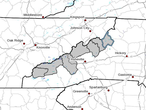
NCZ033-048>052-058-111800-
/O.NEW.KGSP.WS.W.0005.220312T0600Z-220313T0000Z/
/O.NEW.KGSP.WW.Y.0006.220312T0600Z-220313T0000Z/
Avery-Madison-Yancey-Mitchell-Swain-Haywood-Graham-
Including the cities of Ingalls, Banner Elk, Newland, Faust,
Mars Hill, Marshall, Walnut, Allenstand, Hot Springs, Luck,
Swiss, Burnsville, Celo, Micaville, Ramseytown, Busick,
Spruce Pine, Poplar, Alarka, Almond, Bryson City, Luada, Wesser,
Waynesville, Waterville, Canton, Cruso, Cove Creek, Robbinsville,
and Stecoah
450 AM EST Fri Mar 11 2022
…WINTER STORM WARNING IN EFFECT FROM 1 AM TO 7 PM EST SATURDAY
ABOVE 3500 FEET…
…WINTER WEATHER ADVISORY IN EFFECT FROM 1 AM TO 7 PM EST
SATURDAY BELOW 3500 FEET…
- WHAT…For the Winter Storm Warning, heavy snow expected. Total
snow accumulations of up to 6 inches. Winds gusting as high as
45 mph. For the Winter Weather Advisory, snow expected. Total
snow accumulations of up to 3 inches. Winds gusting as high as
35 mph. - WHERE…Counties in western North Carolina along the Tennessee
border. - WHEN…From 1 AM to 7 PM EST Saturday.
- IMPACTS…Travel could be very difficult. Patches of black ice
will develop on bridges and overpasses Saturday morning,
resulting in slippery spots. The cold wind chills as low as 10
below zero could result in hypothermia if precautions are not
taken. - ADDITIONAL DETAILS…Rain will change to snow across the
mountains of North Carolina early Saturday morning, beginning on
the highest peaks and ridgetops of the Smokies around midnight
and down to the valley floors by sunrise, as temperatures fall
quickly below freezing. Snow will taper off to the Tennessee
border by mid- morning, and should end everywhere by sunset
Saturday. Temperatures across the mountains will remain below
freezing through Saturday, so black ice is possible. Winds will
be strong enough to knock down a few tree limbs and power lines
Saturday. The cold temperatures and strong winds will also
result in bitterly cold wind chills Saturday afternoon and
Saturday night at high elevations.
PRECAUTIONARY/PREPAREDNESS ACTIONS…
A Winter Storm Warning for heavy snow means severe winter weather
conditions are expected or occurring. Significant amounts of snow
are forecast that will make travel dangerous. Only travel in an
emergency. If you must travel, keep a flashlight, food, water,
and a warm blanket in your vehicle in case of an emergency.
A Winter Weather Advisory for snow means that periods of snow
will cause primarily travel difficulties. Be prepared for snow
covered roads and limited visibilities, and use caution while
driving.
Please report snow and ice accumulations by calling the National
Weather Service toll free at…1…800…2 6 7…8 1 0 1. Leave a
message with your observation and the specific location where it
occurred. You can also post your report to National Weather
Service Greenville Spartanburg Facebook or tweet your report
using hashtag nwsgsp.
Stay tuned to NOAA Weather Radio or your favorite source of
weather information for the latest updates. Additional details
can be found at www.weather.gov/gsp. The latest state road
conditions can be obtained by calling 5 1 1.