Last Updated on July 17, 2021 6:17 pm
NCZ001>004-018-019-VAZ016-032-172315-
Stokes-Surry-Ashe-Wilkes-Watauga-Alleghany-Patrick-Carroll-
608 PM EDT Sat Jul 17 2021
…A LINE OF STRONG THUNDERSTORMS WILL AFFECT
CENTRAL ALLEGHANY AND SURRY COUNTIES IN NORTHWESTERN NORTH
CAROLINA…NORTHWESTERN STOKES COUNTY IN NORTH CENTRAL NORTH
CAROLINA…WILKES…WATAUGA AND SOUTHEASTERN ASHE COUNTIES IN
NORTHWESTERN NORTH CAROLINA…SOUTH CENTRAL CARROLL AND SOUTHERN
PATRICK COUNTIES IN SOUTHWESTERN VIRGINIA…
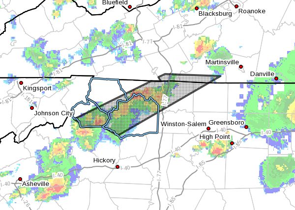
At 608 PM EDT, radar indicated strong thunderstorms were located
along a line extending from Pine Ridge to Seven Devils. Movement was
east at 35 mph.
Winds in excess of 40 mph are possible with these storms.
Locations impacted include…
Boone…
Mount Airy…
North Wilkesboro…
Elkin…
Wilkesboro…
Fairview…
and Flat Rock.
Locally heavy rain will quickly reduce visibility and result in
ponding of water on roadways, standing water in low lying areas, and
minor flooding of creeks, streams, and areas of poor drainage.
Drivers are urged to slow down and use extra caution to avoid
hydroplaning.