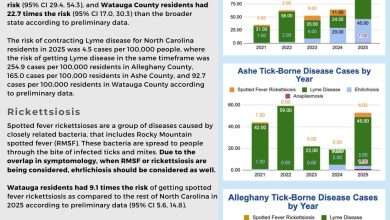
Last Updated on July 4, 2022 6:52 am
Hazardous Weather Outlook
National Weather Service Blacksburg VA
517 AM EDT Mon Jul 4 2022
NCZ001>006-018>020-VAZ007-009>020-022>024-032>035-043>047-058-059-
WVZ042>044-507-508-050930-
Ashe-Alleghany NC-Surry-Stokes-Rockingham-Caswell-Watauga-Wilkes-
Yadkin-Tazewell-Smyth-Bland-Giles-Wythe-Pulaski-Montgomery-Grayson-
Carroll-Floyd-Craig-Alleghany VA-Bath-Roanoke-Botetourt-Rockbridge-
Patrick-Franklin-Bedford-Amherst-Henry-Pittsylvania-Campbell-
Appomattox-Buckingham-Halifax-Charlotte-Mercer-Summers-Monroe-
Eastern Greenbrier-Western Greenbrier-
517 AM EDT Mon Jul 4 2022
This Hazardous Weather Outlook is for north central North Carolina,
northwest North Carolina, central Virginia, south central Virginia,
southwest Virginia, west central Virginia and southeast West
Virginia.
.DAY ONE…Today and tonight.
There is a low probability for widespread hazardous weather.
Isolated afternoon thunderstorms are likely across western North
Carolina and far Southwest Virginia. Locally heavy rainfall can be
expected with the stronger storms.
.DAYS TWO THROUGH SEVEN…Tuesday through Sunday.
An unsettled weather pattern will remain in place through the week as
several complexes of thunderstorms are expected to track
southeastward around the northeastern periphery of a strong upper-
level ridge anchored over the Midwest and Southern Plains. Depending
on the track of these thunderstorm complexes, parts of the forecast
area to potentially the entire forecast area could be impacted.
Widespread damaging thunderstorm wind gusts will be the main hazard
with these thunderstorms. In addition, heavy rainfall could lead to
localized flooding. Such thunderstorm complexes could impact the
forecast area at any time Tuesday through Friday. By Saturday, a cold
front will move into the region bringing widespread thunderstorms,
again some of which could be severe and produce locally heavy
rainfall.
.SPOTTER INFORMATION STATEMENT…
Spotter activation is not anticipated today. Spotter activation is
likely at times Tuesday through Saturday to provide reports on
potentially more widespread severe thunderstorms and areas of
flooding. Reports should be submitted via phone by calling
1-866-215-4324, through our social media platforms, by email at
rnk.skywarn@noaa.gov, or online through our “submit a storm report”
located at www.weather.gov/rnk.