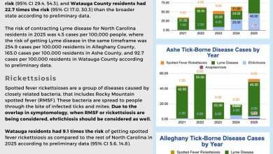
Last Updated on July 1, 2022 6:45 am
Hazardous Weather Outlook
National Weather Service Blacksburg VA
435 AM EDT Fri Jul 1 2022
NCZ001>006-018>020-VAZ044-058-059-021200-
Ashe-Alleghany NC-Surry-Stokes-Rockingham-Caswell-Watauga-Wilkes-
Yadkin-Pittsylvania-Halifax-Charlotte-
435 AM EDT Fri Jul 1 2022
This Hazardous Weather Outlook is for north central North Carolina,
northwest North Carolina and south central Virginia.
.DAY ONE…Today and tonight.
There is a low probability for widespread hazardous weather.
.DAYS TWO THROUGH SEVEN…Saturday through Thursday.
Scattered thunderstorms are expected Saturday with scattered to
numerous thunderstorms Sunday through Thursday. There is a marginal
risk for severe thunderstorms and heavy rainfall Sunday. The main
hazards with any severe thunderstorms will be damaging wind gusts and
possibly quarter-sized hail. Localized flooding will also be
possible where thunderstorms persist or occur repeatedly.
.SPOTTER INFORMATION STATEMENT…
Limited spotter activation is possible Sunday, mainly during the
afternoon and evening, to provide reports of strong winds, wind
damage, and/or hail. Limited spotter activation may also be possible
other days next week. Reports should be submitted via phone by
calling 1-866-215-4324, through our social media platforms, by email
at rnk.skywarn@noaa.gov, or online through our “submit a storm
report” located at www.weather.gov/rnk.