






Last Updated on November 13, 2026 5:35 am
Light snow, gusty winds and much colder air are the story across the High Country today. The National Weather Service in Blacksburg issued this Hazardous Weather Outlook at 3:02 a.m. Friday, and it includes both Watauga and Ashe counties.
Today and Tonight
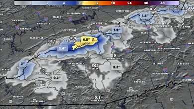
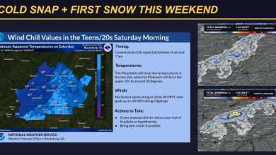
Light measurable snowfall is expected, with the highest elevations seeing 1 to 3 inches. Gusty northwest winds up to 30 mph are also expected. Paired with snow showers, they will cause blowing snow that could reduce visibility at times on the roads.
Saturday Through Thursday
Wind chills in the mid to upper teens are expected Saturday and Sunday mornings, due to the gusty winds and cold temperatures in the 20s.
Counties Included
Watauga and Ashe counties in northwest North Carolina are both included in this outlook. It also covers Tazewell, Smyth, Bland and Grayson counties in southwest Virginia, and Mercer, Summers and Western Greenbrier counties in southeast West Virginia. Avery County is not part of the Blacksburg outlook.
Storm Spotters
The National Weather Service says spotter activation is not expected at this time.
Just Across the Tennessee Line
The National Weather Service in Morristown has a Winter Weather Advisory in effect for elevations above 3,000 feet in the Tennessee mountains, including Johnson and Southeast Carter counties, until 7 a.m. Saturday. Snow totals of 1 to 4 inches are expected there, with gusts up to 35 mph.
Forecast courtesy of the National Weather Service