






Last Updated on November 12, 2026 7:44 am
The High Country’s first snow of the season arrives tonight, as much colder air pours into the mountains and rain showers change over to snow showers. Most valley towns will see little to no accumulation, but the higher elevations could pick up a few inches by Saturday.
When the Snow Starts
Rain showers continue in the western mountains through the day Thursday as waves of energy swing around a large upper-level trough over the eastern U.S. Strong cold air arrives tonight and slowly changes the showers to snow, starting at the higher elevations. According to the National Weather Service in Greenville-Spartanburg, precipitation develops this evening near the Tennessee border and changes to snow after midnight. A light accumulation is possible by daybreak Friday at elevations above 4,000 feet.
How Much Snow to Expect
Upslope snow continues across the western mountains from Thursday night into Friday, with snow showers lasting through midday Saturday. The ground is still warm, so early snow will mostly melt on contact. As the cold settles in, light accumulations are possible, especially on elevated and grassy surfaces.
The National Weather Service in Greenville-Spartanburg shows these expected totals from 7 a.m. Thursday to 7 a.m. Saturday:
- Roan Mountain: 2 to 3 inches
- Beech Mountain: 1 to 2 inches
- Wolf Laurel: 1 to 2 inches
- Max Patch: 1 to 2 inches
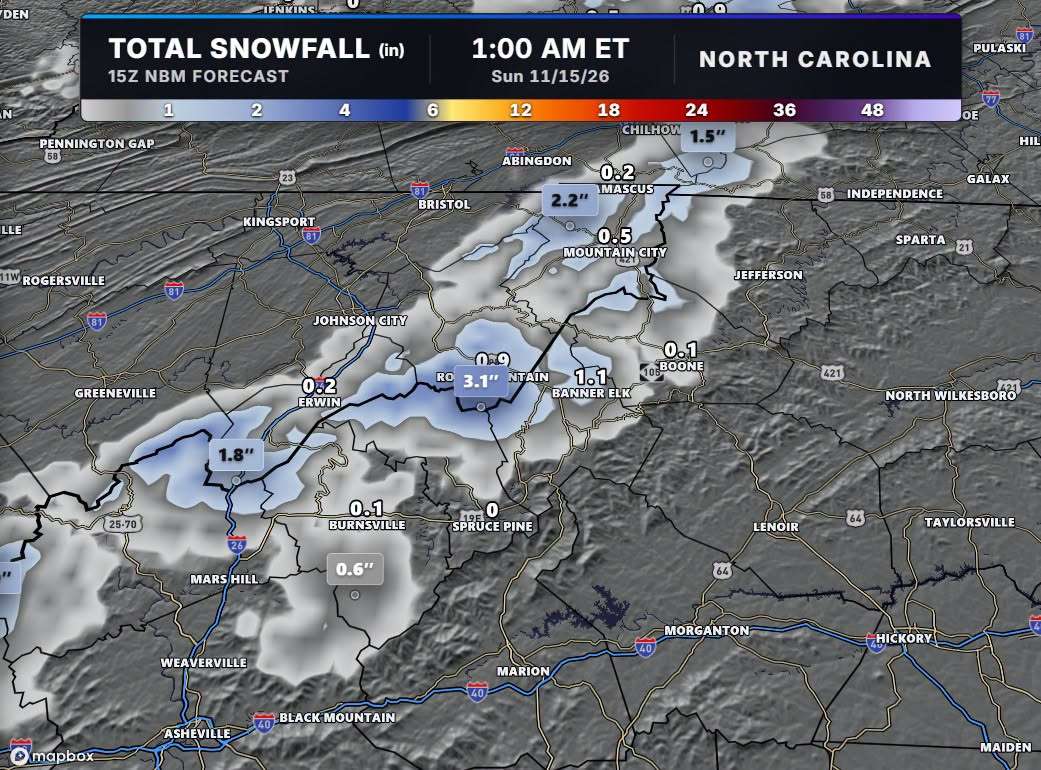
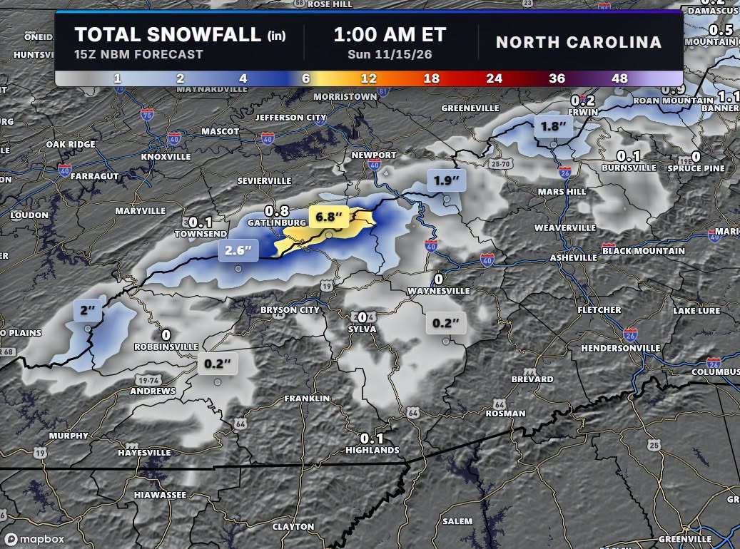
Most of the measurable snow falls along ridgetops and peaks above 5,000 feet. Forecast model maps shared by meteorologist Brad Panovich show a similar pattern: around an inch near Banner Elk, about half an inch near Mountain City, and only a few tenths of an inch or less around Boone. Flurries are possible anywhere along and west of I-81 on Friday.
Hazardous Weather Outlook for Ashe and Watauga Counties
The National Weather Service in Blacksburg issued a Hazardous Weather Outlook at 2:56 a.m. Thursday covering Ashe and Watauga counties in northwest North Carolina, along with Tazewell, Smyth, Bland and Grayson counties in southwest Virginia, and Mercer, Summers and Western Greenbrier counties in southeast West Virginia. An outlook is not a warning or advisory.
- Today and tonight: Hazardous weather is not expected at this time.
- Friday through Wednesday: Light measurable snowfall is expected, with the highest elevations seeing 1 to 3 inches.
- Winds: Gusty northwest winds up to 30 mph, paired with snow showers, will cause blowing snow that could reduce visibility at times on the roads.
The National Weather Service does not expect to need storm spotters at this time.
Winter Weather Advisory Just Across the Tennessee Line
The National Weather Service in Morristown has issued a Winter Weather Advisory for elevations above 3,000 feet in the Tennessee mountains. It covers Johnson County, Southeast Carter County, Unicoi County, Southeast Greene County, the Cocke, Blount and Sevier Smoky Mountains, and Southeast Monroe County.
- When: 7 p.m. Thursday to 7 a.m. Saturday
- What: 1 to 4 inches of snow, locally higher on the highest peaks, with winds gusting as high as 35 mph
- Impacts: Slippery roads that will affect the Thursday evening and Friday morning commutes
Higher-elevation highways that could be affected include Interstate 26 at Sam’s Gap, U.S. 441 at Newfound Gap, U.S. 421 at Trade Gap and TN 165 at Beech Gap on the Cherohala Skyway. Drivers heading into Tennessee should slow down and use caution. Tennessee road conditions are available by calling 511.
Much Colder Through the Weekend
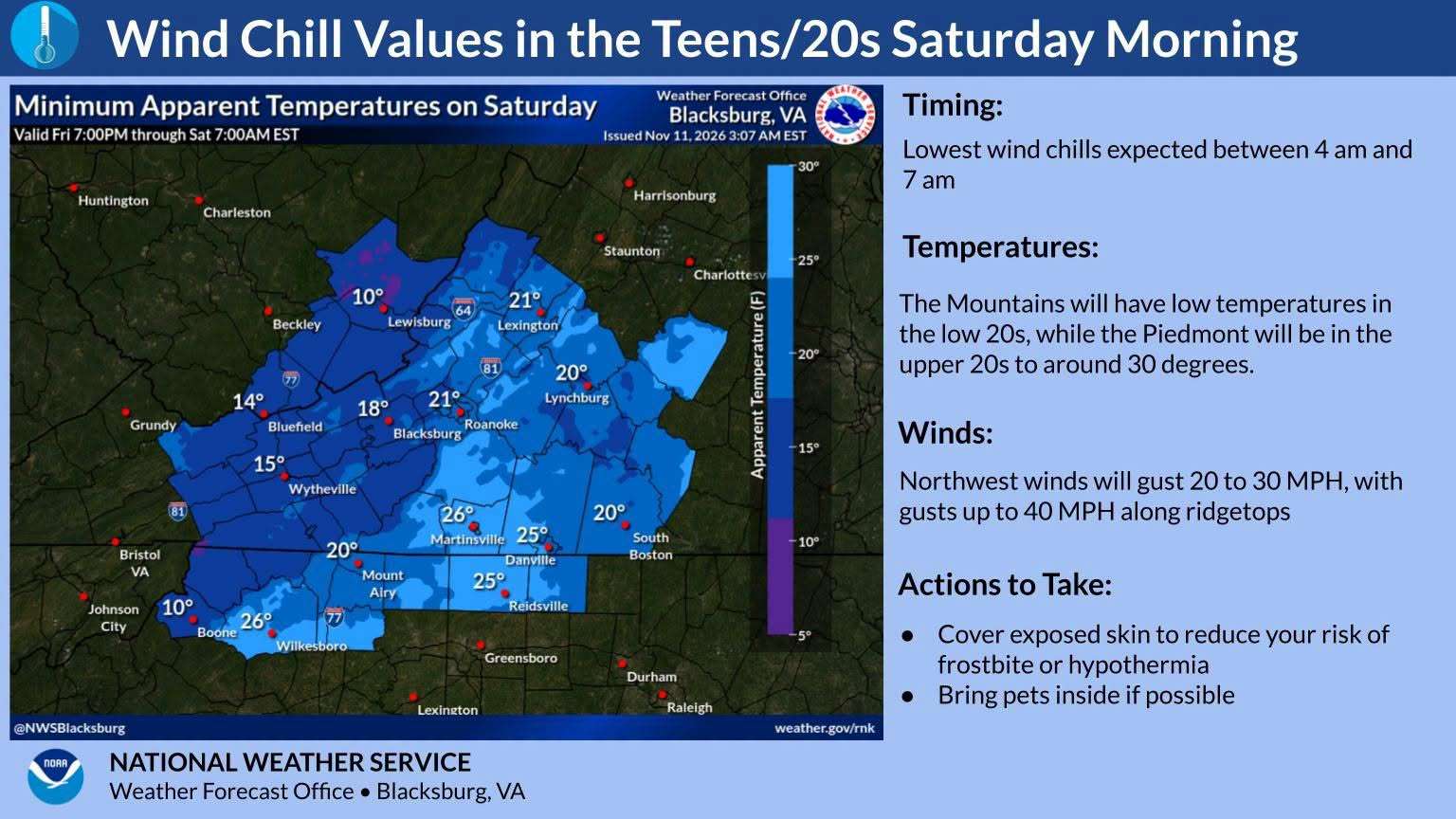
The cold is the bigger story for most people. Highs hold in the 30s to low 40s in the mountains through the weekend, about 15 to 20 degrees below normal west of the Blue Ridge. Lows fall into the 20s Saturday and Sunday nights. Gusty winds keep it feeling colder, with wind chills in the mid to upper teens Saturday and Sunday mornings. The National Weather Service says that isn’t a dangerous level of cold, but it will be a shock after the mild stretch of the past week or so.
Warmer Next Week
Winds go light by Monday as high pressure builds in. Highs return to the 50s by Tuesday and the 60s by Thursday, and no rain is expected all week.
Be Ready
- Bring in pets and cover tender plants before Friday and Saturday nights.
- Allow extra time on mountain roads, especially at higher elevations and Friday morning.
- Watch for blowing snow and reduced visibility on exposed roads.
- Dress in layers for wind chills in the teens.
Forecast courtesy of the National Weather Service. Graphics: NWS Greenville-Spartanburg and NWS Blacksburg. Snowfall model maps: Brad Panovich.