


Last Updated on September 30, 2022 4:38 am
NCZ001>006-018>020-VAZ007-009>019-022-023-032>034-043>045-058-059-
WVZ042>044-301530-
/O.NEW.KRNK.FA.A.0010.220930T1800Z-221001T1800Z/
/00000.0.ER.000000T0000Z.000000T0000Z.000000T0000Z.OO/
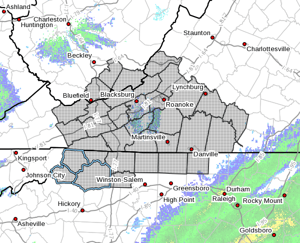
Ashe-Alleghany NC-Surry-Stokes-Rockingham-Caswell-Watauga-Wilkes-
Yadkin-Tazewell-Smyth-Bland-Giles-Wythe-Pulaski-Montgomery-Grayson-
Carroll-Floyd-Craig-Alleghany VA-Roanoke-Botetourt-Patrick-Franklin-
Bedford-Henry-Pittsylvania-Campbell-Halifax-Charlotte-Mercer-Summers-
Monroe-
Including the cities of Clifton Forge, Salem, Blacksburg, Volney,
Keysville, West Jefferson, Sparta, Bland, Pearisburg, Independence,
Rocky Mount, Eden, Lynchburg, Troutdale, Wilkesboro, Union,
Covington, Bedford, Fincastle, Tazewell, Boone, Yanceyville,
Bluefield, Roanoke, Hix, Yadkinville, Floyd, Danville, Dobson, Flat
Top, New Castle, Radford, Martinsville, South Boston, Danbury,
Pulaski, Marion, Hinton, Wytheville, Galax, Whitetop, and Stuart
324 AM EDT Fri Sep 30 2022
…FLOOD WATCH IN EFFECT FROM 2 PM EDT THIS AFTERNOON THROUGH
SATURDAY AFTERNOON…
- WHAT…Flash flooding caused by excessive rainfall is possible.
- WHERE…Portions of North Carolina, Virginia and southeast West
Virginia, including the following counties, in North Carolina,
Alleghany NC, Ashe, Caswell, Rockingham, Stokes, Surry, Watauga,
Wilkes and Yadkin. In Virginia, Alleghany VA, Bedford, Bland,
Botetourt, Campbell, Carroll, Charlotte, Craig, Floyd, Franklin,
Giles, Grayson, Halifax, Henry, Montgomery, Patrick, Pittsylvania,
Pulaski, Roanoke, Smyth, Tazewell and Wythe. In southeast West
Virginia, Mercer, Monroe and Summers. - WHEN…From 2 PM EDT this afternoon through Saturday afternoon.
- IMPACTS…Excessive runoff may result in flooding of rivers,
creeks, streams, and other low-lying and flood-prone locations. - ADDITIONAL DETAILS…
- The remnants of Tropical Cyclone Ian are expected to bring
widespread 2 to 4 inches of rain through Saturday early
afternoon. Locally higher amounts up to 6 inches are also
possible, especially along the Blue Ridge, and any areas
where bands of heavy rain remain situated for extended
periods of time. - For flood safety information, please visit
http://www.weather.gov/safety/flood
PRECAUTIONARY/PREPAREDNESS ACTIONS…
You should monitor later forecasts and be alert for possible Flood
Warnings. Those living in areas prone to flooding should be prepared
to take action should flash flooding occur.


