


Last Updated on September 21, 2021 6:44 am
NCZ001>003-018-019-VAZ009>020-022>024-032>035-043-211800-
/O.NEW.KRNK.FF.A.0010.210921T1800Z-210922T1500Z/
/00000.0.ER.000000T0000Z.000000T0000Z.000000T0000Z.OO/
Ashe-Alleghany NC-Surry-Watauga-Wilkes-Smyth-Bland-Giles-Wythe-
Pulaski-Montgomery-Grayson-Carroll-Floyd-Craig-Alleghany VA-Bath-
Roanoke-Botetourt-Rockbridge-Patrick-Franklin-Bedford-Amherst-Henry-
Including the cities of Roanoke, Wilkesboro, Sparta, Pulaski,
Covington, Independence, Fincastle, Buena Vista, Floyd, Hot Springs,
Clifton Forge, Wytheville, Whitetop, Bedford, Volney, Martinsville,
Pearisburg, Blacksburg, West Jefferson, Lexington, Radford, Boone,
Stuart, New Castle, Dobson, Rocky Mount, Galax, Salem, Marion,
Amherst, Bland, and Troutdale
559 AM EDT Tue Sep 21 2021
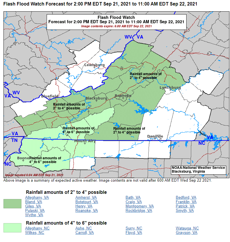
…FLASH FLOOD WATCH IN EFFECT FROM 2 PM EDT THIS AFTERNOON THROUGH
WEDNESDAY MORNING…
The National Weather Service in Blacksburg has issued a
- Flash Flood Watch for portions of North Carolina and Virginia,
including the following areas, in North Carolina, Alleghany NC,
Ashe, Surry, Watauga and Wilkes. In Virginia, Alleghany VA,
Amherst, Bath, Bedford, Bland, Botetourt, Carroll, Craig, Floyd,
Franklin, Giles, Grayson, Henry, Montgomery, Patrick, Pulaski,
Roanoke, Rockbridge, Smyth and Wythe. - From 2 PM EDT this afternoon through Wednesday morning.
- Deep tropical moisture will move across the central Appalachains
this afternoon through tonight, supporting the potential for
prolonged periods of heavy rain. Rainfall amounts will be highest
along and near the crest of the Blue Ridge, where the terrain will
enhance rainfall intensity in the southeasterly windflow. - Where high rainfall rates occur, or where bands of rain pass
repeatedly over the same locations, rapid rises on smaller creeks
and streams is expected. Some of these waterways may flood
outside of their banks, and flow across roads and into low-lying
areas. Depending on where the heaviest rain occurs, minor flooding
of the larger main-stem rivers may be possible.
PRECAUTIONARY/PREPAREDNESS ACTIONS…
You should monitor later forecasts and be prepared to take action
should Flash Flood Warnings be issued.


