


Last Updated on January 15, 2021 3:27 pm
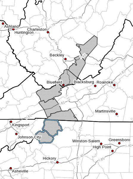
…Two to Four Inches of Snow are Expected Saturday into Saturday Night… .An area of low pressure will cross the region Saturday into Saturday night. Snow will fall from this system starting Saturday morning, and conclude late Saturday night. Around two to four inches of snow are expected to accumulate at the highest elevations, especially those at or above 3000 ft.
NCZ001-018-VAZ007-009-015-WVZ042-043-508-160430-
/O.NEW.KRNK.WW.Y.0004.210116T1200Z-210117T1200Z/
Ashe-Watauga-Tazewell-Smyth-Grayson-Mercer-Summers-
Western Greenbrier-
Including the cities of West Jefferson, Boone, Tazewell, Marion,
Independence, Whitetop, Troutdale, Volney, Bluefield, Hinton,
Hix, Quinwood, Duo, and Rainelle
324 PM EST Fri Jan 15 2021
…WINTER WEATHER ADVISORY IN EFFECT FROM 7 AM SATURDAY TO 7 AM
EST SUNDAY…
- WHAT…Snow expected. Total snow accumulations of up to 4
inches, isolated 5 inches in western Greenbrier County. Winds
gusting as high as 35 mph. - WHERE…Portions of southwest Virginia, northwest North
Carolina and southeast West Virginia. - WHEN…From 7 AM Saturday to 7 AM EST Sunday.
- IMPACTS…Plan on slippery road conditions.
PRECAUTIONARY/PREPAREDNESS ACTIONS…
A Winter Weather Advisory for snow means that periods of snow
will cause travel difficulties. Be prepared for snow covered
roads and limited visibilities…and use caution while driving.
Please report snow, sleet or ice accumulations via email at
rnk.skywarn@noaa.gov or by calling the National Weather Service
toll free at…1…866…2 1 5…4 3 2 4. Leave a message with
your observation and the specific location where it occurred. You
can also post your report to National Weather Service Blacksburg
Facebook page and on Twitter.
The latest road conditions for the state you are calling from can
be obtained by calling 5 1 1.


