Last Updated on February 12, 2022 6:35 pm
*check back here for updates on conditions for Wednesday*
NCZ033-048>052-058-059-061200-
AVERY-MADISON-YANCEY-MITCHELL-SWAIN-HAYWOOD-GRAHAM-NORTHERN JACKSON-
INCLUDING THE CITIES OF…NEWLAND…SPRUCE PINE…CHEROKEE…
BRYSON CITY…WAYNESVILLE…SYLVA
104 AM EST WED MAR 6 2013
…HIGH SNOWFALL RATES TO AFFECT THE WESTERN NORTH CAROLINA MOUNTAINS THROUGH THE EARLY MORNING HOURS…
SNOWFALL RATES ACROSS THE TENNESSEE BORDER COUNTIES OF THE NORTH CAROLINA MOUNTAINS WILL INCREASE RAPIDLY THROUGH THE EARLY MORNING HOURS…WITH SOME LOCATIONS SEEING 1 TO 2 INCH PER HOUR SNOWFALL RATES AT TIMES.
IN ADDITION…STRONG NORTHWEST WINDS OF 20 TO 30
MPH WITH GUSTS NEAR 50 MPH WILL CREATE NEAR BLIZZARD CONDITIONS IN SOME LOCATIONS…WITH BLOWING SNOW REDUCING VISIBILITY BELOW ONE QUARTER MILE AT TIMES.
Wind gusts over 50mph along with falling and blowing snow making hazardous conditions
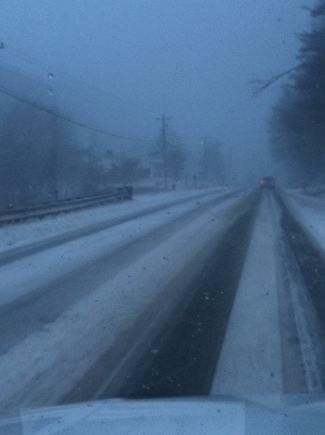
1:30am – snow continues to stick to area roads after snow starting falling late Tuesday night. More updates coming starting around 5am.
See the closings page for school closings
5:10am via twitter – @WataugaRoads 321 into boone is snow covered with 1 wet lane in each direction. 421 is wet with patches of snow.
Mention: @WataugaRoads 194 is snow covered with wet spots and Howard's Creek rd, like most secondary roads hasn't been scraped yet.
Mention: @WataugaRoads Be careful of windy spots, I had to stop in the road for whiteouts, a few times.
Mar 06, 2013 5:12 AM
Sugar Grove [Watauga Co, NC] fire dept/rescue reports SNOW of E1.0 INCH at 05:15 AM EST bit.ly/105jan1
Not a good morning for early travel, snow covered roads and high winds are the major factors, and single digit wind chills.
King Street in Boone at 6am

184 in Banner Elk at 6am

All local schools are closed and all ASU classes that meet before 11 a.m. Wednesday, March 6, are cancelled. http://wataugaroads.com/closingscancellations/
6:19am – 105 at Smoketree Lodge in Foscoe is closed due to jackknifed truck
105 in Foscoe at 6:30am – http://wataugaroads.com/cams/

6:30am – 105 in Foscoe is a MESS. One jack knifed truck and another spinning near the county line
Valle Crucis [Watauga Co, NC] trained spotter reports SNOW of M1.8 INCH at 06:35 AM EST bit.ly/13EUNAU?RNK
Industrial park in Boone 6:55am. Photo:Andy Rominger

Downtown Boone at 7:05am

105 in Foscoe at 7:10am

With gusts up to 60mph forecast today white out conditions are going to be a problem all day and into tonight.
Peak wind gusts in Boone so far 52mph at 1:55am. Gusts of 38, 30, 45 and 32 since 5am
105 bypass at 7:30am
Deerfield at the golf course 7:30am http://iruntrails.tumblr.com/post/44702186399/deerfield-at-the-golf-course-wataugaroads#_=_
Snow blowing around on King Street at 7:35am. Photo Resortcams.com & http://wataugaroads.com/cams/

7:45am via twitter – Howards Crk covered slick. 194 DOT – 421 wet blacktop. 421S – BRP 90% clear. Brp – wilkes. Line wet. 421-wilkeboro bone dry
Winter Storm Warning remains until 6am Thursday morning
8:15am – Old 421 at Food Lion and intersection of 421 and Old 421


8:35am – tractor & trailer stuck in the curve of Deerfield and Wilson's Ridge
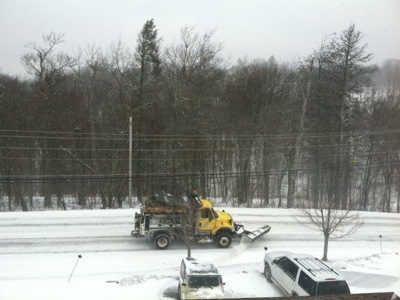
8:20 – DOT's orange truck makes its way up Niley Cook Road amidst blowing snow and 18 degree temperature. Photo:Curly Stumb

Wind gusts of 52mph at 8:15am in Boone ties the highest of the day. The other occurred at 1:55am
Downtown Boone at 8:47am. Photo Resortcams.com & http://wataugaroads.com/cams/

Boone [Watauga Co, NC] co-op observer reports SNOW of M2.0 INCH at 07:00 AM ESTbit.ly/13F1GSQ?RNK
Beech Mountain [Watauga Co, NC] law enforcement reports SNOW of E5.0 INCH at 09:03 AM EST bit.ly/13F8WOM?RNK
via Boone PD 9:12am -Roads in town are snow covered and slick. Use caution when traveling.
via tiwtter – @WataugaRoads Not sure If it's the same one. Truck stuck at Deerfield and Wilson's Ridgepic.twitter.com/owiZDr27Op
9:18am via facebook – Just came up 321 from Lenoir to Boone and the roads are decent. A few snow covered spots, but mostly just wet. The worst part is the wind and snow blowing, making it hard to see.
NWS Video update
UPDATE 9:30AM – ASU – All classes that begin before 5 p.m. on Wednesday, March 6, have been cancelled. A decision about evening classes will be made by 3 p.m.
Road conditions vary throughout the county. Individuals should use their own judgment regarding travel to campus. Employees unable to report to work should refer to the Adverse Weather policy: http://policy.appstate.edu/Adverse_Weather_and_Emergency_Closing.
Monitor AppalCart (www.appalcart.com) for schedule changes. Monitor campus email, www.appstate.edu, AppalNet, MyASU and Twitter at @appstateclosing for updates.
Wednesday March 6, 2013 AppalCART will be closed until 4pm. Decision on night service will be made by 3pm.
SPOTTER REPORTS
NATIONAL WEATHER SERVICE BLACKSBURG VA
808 AM EST WED MAR 06 2013
THE FOLLOWING ARE UNOFFICIAL OBSERVATIONS TAKEN DURING THE PAST 8
HOURS FOR THE STORM THAT HAS BEEN AFFECTING OUR REGION. APPRECIATION
IS EXTENDED TO THOSE WHO PROVIDED REPORTS. THIS SUMMARY IS ALSO
AVAILABLE ON OUR HOME PAGE AT WEATHER.GOV/BLACKSBURG
********************STORM TOTAL SNOWFALL********************
LOCATION STORM TOTAL TIME/DATE COMMENTS
SNOWFALL OF
/INCHES/ MEASUREMENT
NORTH CAROLINA
…ASHE COUNTY…
WEST JEFFERSON 1.6 743 AM 3/06 VIA FACEBOOK
TROUT 1.0 1230 AM 3/06 PUBLIC
…WATAUGA COUNTY…
VALLE CRUCIS 1.8 635 AM 3/06 TRAINED SPOTTER
SUGAR GROVE 1.0 515 AM 3/06 FIRE DEPT/RESCUE
Clarks Creek Rd near Justus bridge in Valle Crucis at 9am. Photo: Stuart Scott

per <a href="https://www.facebook.com/whspioneers?ref=stream" target="_blank">Watauga High Pioneer Athletics facebook page</a> – All athletic events, including practices have been postponed due to inclement weather for today.
10:40am – over the last two hours wind gusts continue in the mid to upper 40mph range.
SPOTTER REPORTS
NATIONAL WEATHER SERVICE BLACKSBURG VA
1032 AM EST WED MAR 06 2013
THE FOLLOWING ARE UNOFFICIAL OBSERVATIONS TAKEN DURING THE PAST 9
HOURS FOR THE SNOW THAT HAS BEEN AFFECTING OUR REGION. APPRECIATION
IS EXTENDED TO THOSE WHO PROVIDED REPORTS. THIS SUMMARY IS ALSO
AVAILABLE ON OUR HOME PAGE AT WEATHER.GOV/BLACKSBURG.
********************STORM TOTAL SNOWFALL********************
LOCATION STORM TOTAL TIME/DATE COMMENTS
SNOWFALL OF
/INCHES/ MEASUREMENT
NORTH CAROLINA
…ASHE COUNTY…
3 SW CRESTON 2.2 845 AM 3/06 COCORAHS
6 NW LANSING 2.0 800 AM 3/06 COCORAHS
WEST JEFFERSON 1.6 743 AM 3/06 VIA FACEBOOK
2 E TODD 0.9 700 AM 3/06 COCORAHS
2 WSW GLENDALE SPRIN 0.3 800 AM 3/06 COCORAHS
…WATAUGA COUNTY…
BEECH MOUNTAIN 5.0 903 AM 3/06 LAW ENFORCEMENT
1 SE BEECH MOUNTAIN 3.0 530 AM 3/06 COCORAHS
BOONE 2.0 700 AM 3/06 CO-OP OBSERVER
1 SSE VALLE CRUCIS 2.0 800 AM 3/06 COCORAHS
VALLE CRUCIS 1.8 635 AM 3/06 TRAINED SPOTTER
5 ESE BANNER ELK 1.5 800 AM 3/06 COCORAHS
SUGAR GROVE 1.0 515 AM 3/06 FIRE DEPT/RESCUE
4 NE BLOWING ROCK 0.5 700 AM 3/06 COCORAHS
5 E BOONE 0.3 800 AM 3/06 COCORAHS
10:20am – Hairpin turn on Niley Cook Road is wet and improving. High wind gusts still blowing snow around. Photo: Curly Stumb

Beech Mtn Parkway 10:20am
Blowing Rock [Watauga Co, NC] trained spotter reports SNOW of E3.0 INCH at 10:49 AM EST bit.ly/13Fm4U7?RNK
10:55am – still no reported power outages in the Blue Ridge Electric member area
Windy in Vilas. Video from Steve Marks
Watauga County Schools will be closed for students and teachers on Thursday March 7 – http://wataugaroads.com/closingscancellations/
All ASU evening classes have been cancelled for Wednesday, March 6.
Johnson County TN Schools will be closed Thursday March 7
3:26pm – power outages in the Blue Ridge Electric member area – Watauga 115
Mini snow whirl in Vilas. Video:Steve Marks http://twitter.yfrog.com/jnb61okjhaptcvixatftrmhbz
Still getting late evening reports of slick roads in Watauga – Bethel Road and Hattie Hill Road, Mountain Dale Road to name a few
Event extended (both time and area). Winter Weather Advisory from 3/6/2013 7:24 PM to 3/7/2013 10:00 AM EST for Avery County. http://1.usa.gov/XTL1XY
Event extended (both time and area). Winter Weather Advisory from 3/6/2013 7:25 PM to 3/7/2013 10:00 AM EST for Ashe County, Watauga http://1.usa.gov/YA7Hvx
Winter Storm Warning is CANCELLED but Winter Weather Advisory is up until 10am Thursday